Interstate State Park
| Interstate Park | |
| Minnesota State Park, Wisconsin State Park | |
|
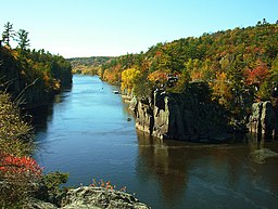
The Dalles of the St. Croix River seen from the Wisconsin bank
|
|
| Country | United States |
|---|---|
| States | Minnesota, Wisconsin |
| Counties | Chisago County, Minnesota, Polk County, Wisconsin |
| City | Taylors Falls, Minnesota, St. Croix Falls, Wisconsin |
| Elevation | 886 ft (270 m) |
| Coordinates | 45°23′30″N 92°39′55″W / 45.39167°N 92.66528°WCoordinates: 45°23′30″N 92°39′55″W / 45.39167°N 92.66528°W |
| Area | 1,628 acres (659 ha) |
| Founded | 1895 |
| Management | Minnesota Department of Natural Resources, Wisconsin Department of Natural Resources |
| Unit of | Ice Age National Scientific Reserve |
|
Interstate State Park WPA/Rustic Style Historic District
|
|

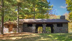
1939 Refectory built by the WPA, now the Minnesota park's visitor center
|
|
| Location | Off U.S. Hwy. 8, Shafer Township |
|---|---|
| Nearest city | Taylors Falls, Minnesota |
| Coordinates | 45°24′0″N 92°39′4″W / 45.40000°N 92.65111°W |
| Area | 6 acres (2.4 ha) |
| Built | c. 1920–1939 |
| Architectural style | National Park Service rustic |
| MPS | Minnesota State Park CCC/WPA/Rustic Style MPS |
| NRHP Reference # | 89001664 |
| Added to NRHP | June 11, 1992 |
|
Interstate State Park CCC/WPA/Rustic Style Campground
|
|

1938 Shelter/Refectory built by the WPA
|
|
| Location | Off US 8 SW of Taylors Falls, Shafer Township |
|---|---|
| Nearest city | Taylors Falls, Minnesota |
| Coordinates | 45°23′33″N 92°40′8″W / 45.39250°N 92.66889°W |
| Area | 22 acres (8.9 ha) |
| Built | 1938, 1941 |
| Architectural style | National Park Service rustic |
| MPS | Minnesota State Park CCC/WPA/Rustic Style MPS |
| NRHP Reference # | 92000638 |
| Added to NRHP | June 11, 1992 |
Interstate Park comprises two adjacent state parks on the Minnesota–Wisconsin border, both named Interstate State Park. They straddle the Dalles of the St. Croix River, a deep basalt gorge with glacial potholes and other rock formations. The Wisconsin park is 1,330 acres (538 ha) and the Minnesota park is 298 acres (121 ha). The towns of Taylors Falls, Minnesota and St. Croix Falls, Wisconsin are adjacent to the park. Interstate Park is within the Saint Croix National Scenic Riverway and the Ice Age National Scientific Reserve. The western terminus of the Ice Age National Scenic Trail is on the Wisconsin side. On the Minnesota side, two areas contain National Park Service rustic style buildings and structures that are listed on the National Register of Historic Places.
1.1 billion years ago, a series of volcanic eruptions from the Midcontinent Rift System sent at least ten separate lava flows across the region that now includes Interstate Park. These flows hardened into basalt, which fractured at several joints. In the Cambrian period, between 530 and 470 million years ago, the region was covered by a shallow sea which deposited sandstone and siltstone atop the basalt. This epoch of the Cambrian, the Furongian, was originally called the Croixian in North America because the layers exposed in this area were its type locality.
...
Wikipedia


