Interstate 790 (New York)
| Interstate 790 | ||||
|---|---|---|---|---|

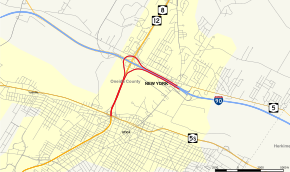
Map of Utica in Oneida County with I-790 highlighted in red
|
||||
| Route information | ||||
| Maintained by NYSDOT | ||||
| Length: | 2.29 mi (3.69 km) | |||
| Existed: | 1960s – present | |||
| Major junctions | ||||
| West end: |
|
|||
| East end: |
|
|||
| Highway system | ||||
|
||||
Interstate 790 (I-790) is an auxiliary Interstate Highway in the city of Utica, New York, in the United States. It runs for 2.29 miles (3.69 km) from an interchange with New York State Route 5A (NY 5A) and NY 5S in downtown Utica to a pair of interchanges with Genesee Street east of the city. All of I-790 is concurrent with NY 5, and the portion south of NY 49 is also concurrent with NY 8 and NY 12. I-790 connects to exit 31 of the New York State Thruway (I-90) by way of an interchange near its east end. According to the New York State Department of Transportation (NYSDOT), I-790 follows NY 5 to Genesee Street while the highway leading to Thruway exit 31 is merely a pair of ramps connecting I-790 to its parent. The north–south portion of I-790 between its western terminus and NY 49 is named the North–South Arterial Highway.
I-790 begins at an interchange connecting NY 5A and NY 5S to the North–South Arterial (NY 5, NY 8, and NY 12) on the northern edge of the city of Utica. The route heads northeast from this point, overlapping with NY 5, NY 8, and NY 12 along a six-lane limited-access highway leading away from downtown. As the road leaves the NY 5A and NY 5S junction, it crosses over the CSX Transportation's Mohawk Subdivision rail line, which runs along the northern edge of the interchange. Past the tracks, the dense commercial and residential blocks that comprise downtown Utica give way to a mostly undeveloped strip of land surrounding the Mohawk River and Erie Canal. I-790 continues on a northeasterly track across the open area, crossing the Mohawk River and an abandoned railroad grade just north of the waterway.
...
Wikipedia

