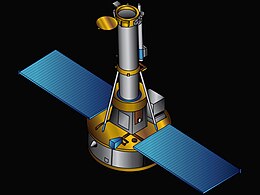
Interface Region Imaging Spectrograph

The Interface Region Imaging Spectrograph
|
|
| Mission type | Solar UV astronomy |
|---|---|
| Operator | NASA |
| COSPAR ID | 2013-033A |
| SATCAT no. | 39197 |
| Mission duration | 2 years (planned) |
| Spacecraft properties | |
| Manufacturer | Lockheed Martin |
| Launch mass | 183 kg (403 lb) |
| Start of mission | |
| Launch date | 27 June 2013, 02:27:46 UTC |
| Rocket | Pegasus-XL F42 |
| Launch site | Stargazer, Vandenberg |
| Contractor | Orbital Sciences |
| Orbital parameters | |
| Reference system | Geocentric |
| Regime | Sun-synchronous |
| Semi-major axis | 7,015.38 km (4,359.16 mi) |
| Eccentricity | 0.0029478 |
| Perigee | 623 km (387 mi) |
| Apogee | 665 km (413 mi) |
| Inclination | 97.90 degrees |
| Period | 97.47 minutes |
| Epoch | 24 January 2015, 02:50:49 UTC |
|
|
|
The Interface Region Imaging Spectrograph (IRIS) is a NASA solar observation satellite. The mission was funded through the Small Explorer program to investigate the physical conditions of the solar limb, particularly the chromosphere of the Sun. The spacecraft consists of a satellite bus and spectrometer built by the Lockheed Martin Solar and Astrophysics Laboratory (LMSAL), and a telescope provided by the Smithsonian Astrophysical Observatory. IRIS is operated by LMSAL and NASA's Ames Research Center.
The satellite's instrument is a high-frame-rate ultraviolet imaging spectrometer, providing one image per second at 0.3 arcsecond angular resolution and sub-ångström spectral resolution.
NASA announced on 19 June 2009 that IRIS was selected from six Small Explorer mission candidates for further study, along with the Gravity and Extreme Magnetism (GEMS) space observatory.
The spacecraft arrived at Vandenberg Air Force Base, California, on 16 April 2013 and was successfully launched on 27 June 2013 by a Pegasus-XL rocket.
IRIS achieved first light on 17 July 2013. NASA noted, "IRIS's first images showed a multitude of thin, fibril-like structures that have never been seen before, revealing enormous contrasts in density and temperature occur throughout this region even between neighboring loops that are only a few hundred miles apart." On 31 October 2013, calibrated IRIS data and images were released on the project website. A preprint describing the satellite and initial data has been released on the arXiv.
Data collected from the IRIS spacecraft has shown that the interface region of the sun is significantly more complex than previously known. This includes features described as solar heat bombs, high-speed plasma jets, nano-flares, and mini-tornadoes. These features are an important step in understanding the transfer of heat to the corona.
...
Wikipedia
