Inje
|
Inje 인제군 |
||
|---|---|---|
| County | ||
| Korean transcription(s) | ||
| • Hangul | ||
| • Hanja | ||
| • Revised Romanization | Inje-gun | |
| • McCune-Reischauer | Inje-gun | |
|
||
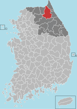
 Location in South Korea |
||
| Country |
|
|
| Region | Gwandong | |
| Administrative divisions | 1 eup, 5 myeon | |
| Area | ||
| • Total | 1,646.33 km2 (635.65 sq mi) | |
| Population (2000) | ||
| • Total | 34,120 | |
| • Density | 21/km2 (50/sq mi) | |
| • Dialect | Gangwon | |
Inje County (Inje-gun) is a county in Gangwon Province, South Korea. It has the lowest population density of any South Korean county.
Since the first inhabitants came to the Korean peninsula, there have been people living in Inje county. Surrounded by clear and clean rivers and streams and magnificent Soraksan. Inje is located in the mid-east of Gangwon-do, it was at first called Jeojokhyeon in the Goguryeo Kingdom, Heejaehyeon in the Silla Kingdom, Inje in the Goryeo Dynasty, Youngsohyeon and again later Inje in the Joseon Dynasty and finally raised to the status of Inje county in August 1896.
The 2nd Infantry Division recaptured Inje town in Operation Rugged in April 1951 as the UN Forces advanced to Line Kansas, north of the 38th Parallel.
Inje town was lost again to the Chinese People's Volunteer Army during the Fifth Phase Offensive in late April 1951 and was recaptured in the UN counteroffensive to Line Kansas that followed in late May 1951.
In 1951 the US Marine Corps 1st Medical Battalion operated a field hospital in Inje town.
The 40th Infantry Division assumed responsibility for the defense of Line Kansas from the 24th Infantry Division from February 1952 supported by the ROK 3rd Infantry Division.
Inje is located in the Taebaek Mountains and has a landscape dominated by Flora. Many species inhabit several areas of the county, not only mountains but rivers also.
Daecheong Peak is the highest peak in the Mt. Seorak ranges and is located near at the boundary of Inje county and Yangyang county with an altitude of 1,708m.
...
Wikipedia

