Ingatestone
| Ingatestone | |
|---|---|
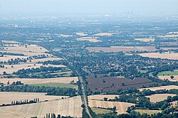
 Aerial picture of Ingatestone |
|
| Ingatestone shown within Essex | |
| Population | 4,504 |
| OS grid reference | TQ645995 |
| Civil parish | |
| District | |
| Shire county | |
| Region | |
| Country | England |
| Sovereign state | United Kingdom |
| Post town | INGATESTONE |
| Postcode district | CM4 |
| Dialling code | 01277 |
| Police | Essex |
| Fire | Essex |
| Ambulance | East of England |
| EU Parliament | East of England |
| UK Parliament | |
Ingatestone (anciently Ingerston, Ingerstone, Ingarston, Ingaston, etc.) is a village in Essex, England, with a population of about 4,500 people. To the immediate north lies the village of Fryerning, and the two form the civil parish of Ingatestone and Fryerning.
Ingatestone sits within an area of Metropolitan Green Belt land, 20 miles (32 km) north east of London. The built-up area is largely situated between the A12 and the Great Eastern Railway. Today it is an affluent commuter town. Due to its rural yet well-serviced setting, the demographic is a mixture of young and old, skilled and unskilled, with a lure for the commercial and agricultural worker.
Ingatestone was established in Saxon times on the Essex Great Road (A12) that runs between the two Roman towns of London and Colchester. The name, derived from the Middle English Yenge-atte-Stone, and also Latinised as Ginge ad Petram, means parcel of land at the stone, also seen as 'Gynge atte Stone' in 1430.
Stone is not prevalent in the local geology, making the town's stone—deposited by glacial action—unusual for the area. The stone can still be seen, split into three stones, one by the west door of the church and one each side of the entrance to Fryerning Lane.
By the time of the Domesday Book in 1086, Fryerning and Ingatestone (Inga) were recorded as being in the Hundred of Chelmsford and part of the land of St Mary of Barking with a value of 60 shillings (£3), which was held by Robert Gernon in demesne.
...
Wikipedia

