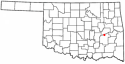
Indianola, Pittsburg County, Oklahoma
| Indianola, Oklahoma | |
|---|---|
| Town | |
 Location of Indianola, Oklahoma |
|
| Coordinates: 35°9′44″N 95°46′33″W / 35.16222°N 95.77583°WCoordinates: 35°9′44″N 95°46′33″W / 35.16222°N 95.77583°W | |
| Country | United States |
| State | Oklahoma |
| County | Pittsburg |
| Area | |
| • Total | 0.3 sq mi (0.8 km2) |
| • Land | 0.3 sq mi (0.8 km2) |
| • Water | 0.0 sq mi (0.0 km2) |
| Elevation | 653 ft (199 m) |
| Population (2010) | |
| • Total | 162 |
| • Density | 520.2/sq mi (200.8/km2) |
| Time zone | Central (CST) (UTC-6) |
| • Summer (DST) | CDT (UTC-5) |
| ZIP code | 74442 |
| Area code(s) | 539/918 |
| FIPS code | 40-36950 |
| GNIS feature ID | 1094100 |
Indianola is a town in Pittsburg County, Oklahoma, United States. The population was 162 at the 2010 census, a loss of 15.8 percent compared to 191 at the 2000 census.
Indianola probably began in 1875, when H. M. McElhany moved to the area and opened a one-room store. The store also served as a mail drop for local residents. The mail was delivered by horseback from the nearby town of Canadian, Oklahoma. McElhany stayed in business for about three years, then sold the store to Albert S. Cornelison and James H. Bynum. An actual post office was established on January 16, 1891, with Bynum being appointed as the first postmaster.
According to the Encyclopedia of Oklahoma History and Culture, there are two versions of how the community acquired its name. One version says the name was on a stove in the general store. The other version says that the name honored Indianola, Mississippi.
The first school in Indianola was organized in February 1895. In 1898, Lyman H. Perkins, a Choctaw farmer who had originally all the land on which Indianola was built, donated 1 acre (0.40 ha) for construction of a Methodist church. In 1902, the Fort Smith and Western Railway built a track north of town. Indianola quickly relocated to be adjacent to the track, and the residents built a new school building. Lyman Perkins and his wife donated 4 acres (1.6 ha) to the new town, which retained the name Indianola. The former site was simply called "Old Town." By 1910, the community claimed 781 residents, which was the all-time high.
Indianola is located at 35°9′44″N 95°46′33″W / 35.16222°N 95.77583°W (35.162229, -95.775836) It is located on the south bank of the South Canadian River, about 18 miles (29 km) north of McAlester. According to the United States Census Bureau, the town has a total area of 0.3 square miles (0.78 km2), all of it land. Indianola is 211 meters above sea level.
...
Wikipedia
