Inchkeith
| Gaelic name | Innse Coit |
|---|---|
| Meaning of name | wooded island or Coeddi's island |
| Location | |
|
Inchkeith shown within the Firth of Forth
|
|
| OS grid reference | NT293826 |
| Coordinates | 56°02′00″N 3°08′06″W / 56.033333°N 3.135°W |
| Physical geography | |
| Island group | Islands of the Forth |
| Area | 22.9 hectares (57 acres) |
| Highest elevation | 60 m |
| Administration | |
| Sovereign state | United Kingdom |
| Country | Scotland |
| Council area | Fife |
| Demographics | |
| Population | 0 |
| References | |

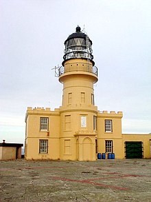
Inchkeith Lighthouse
|
|
|
Scotland
|
|
| Location | Inchkeith Fife |
|---|---|
| Coordinates | 56°02′00″N 3°08′12″W / 56.033232°N 3.136643°W |
| Year first constructed | 1804 |
| Automated | 1986 |
| Construction | stone tower |
| Tower shape | cylindrical tower with balcony and lantern attached to a 2-storey keeper’s house |
| Markings / pattern | ochre tower and building, black lantern |
| Height | 19 metres (62 ft) |
| Focal height | 67 metres (220 ft) |
| Light source | diesel engineers |
| Intensity | 269,280 candela |
| Range | 22 nautical miles (41 km; 25 mi) |
| Characteristic | Fl W 15s. |
| Admiralty number | A2912 |
| NGA number | 2388 |
| ARLHS number | SCO-107 |
| Managing agent |
Forth Ports |
Forth Ports
Inchkeith (from the Scottish Gaelic: Innis Cheith) is an island in the Firth of Forth, Scotland, administratively part of the Kinghorn parish of the county of Fife.
Inchkeith has had a colourful history as a result of its proximity to Edinburgh and strategic location for use as home for a lighthouse and for military purposes defending the Firth of Forth from attack from shipping, and more recently protecting the upstream Forth Bridge and Rosyth Dockyard. Inchkeith has, by some accounts, been inhabited (intermittently) for almost 1,800 years.
Inchkeith is approximately half the size of the Isle of May at the mouth of the Firth, but is higher.
Although most of the island is of volcanic origin, the island’s geology is surprisingly varied. As well as the igneous rock, there are also some sections of sandstone, shale, coal and limestone. The shale contains a great number of fossils. There are several springs on the island.
The island has the lowest average rainfall in Scotland at 550 millimetres (21.7 in) annually.
The island has an abundance of springs, as noted by James Grant. James Boswell noted two wells on the island during his visit, and speculated as to the former existence of a third within the Castle.
The name "Inchkeith" may derive from the medieval Scottish Gaelic Innse Coit, meaning "wooded island". The latter element coit, in Old Welsh coet, is from the Proto-Celtic *cēto-, "wood". The late 9th century Sanas Cormaic, authored by Cormac mac Cuilennáin, suggests that the word had disappeared from the Gaelic of Ireland by that period, becoming coill; he states "coit coill isin chombric", that is, "coit is Welsh for wood", and explains that the Irish place-name Sailchoit is partly derived from Welsh. Although Scottish Gaelic was closer to Brythonic than Irish was, the Life of St Serf (written before 1180) calls the island Insula Keð, suggesting the possibility that the specific element in Inchkeith was not comprehensible to that hagiography's anonymous author or translator; if we could be sure that the author was Scottish, rather than an English or French incomer, this could be taken to mean that the word was probably not comprehensible even in Fife Gaelic in the 12th century. Since Gaelic had all but disappeared as a language spoken natively in southern Fife by the mid-14th century, there is no continuous Gaelic tradition for the name, but the modern form is Innis Cheith.
...
Wikipedia


