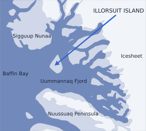
Illorsuit Island

Location of Illorsuit Island
|
|
| Geography | |
|---|---|
| Location | Uummannaq Fjord |
| Coordinates | 71°10′N 53°43′W / 71.167°N 53.717°WCoordinates: 71°10′N 53°43′W / 71.167°N 53.717°W |
| Area | 468 km2 (181 sq mi) |
| Administration | |
|
Greenland
|
|
| Municipality | Qaasuitsup |
Illorsuit Island (Greenlandic: Illorsuip qeqertaat, Danish: Ubekendt Ejland) is an island in the Qaasuitsup municipality in northwestern Greenland.
The island is pear-shaped, and at 468 km2 (180.7 sq mi), it is the second-largest island in the Uummannaq Fjord system, located to the east of its mouth, between Sigguup Nunaa peninsula in the north and Nuussuaq Peninsula in the south.
Illorsuit is the only settlement on the island, located on the northeastern coast of the island.
...
Wikipedia
