IJsselmeer
| IJsselmeer | |
|---|---|

Landsat photo
|
|
 |
|
| Location | Northern Netherlands |
| Coordinates | 52°49′N 5°15′E / 52.817°N 5.250°ECoordinates: 52°49′N 5°15′E / 52.817°N 5.250°E |
| Lake type | artificial lake |
| Primary inflows | IJssel, Vechte |
| Primary outflows | North Sea |
| Basin countries | Netherlands |
| Surface area | 1,100 km2 (420 sq mi) |
| Average depth | 5.5 m (18 ft) |
| Max. depth | 7 m (23 ft) |
| Surface elevation | −0.4 m (−1.3 ft) (winter) −0.2 m (−0.66 ft) (summer) |
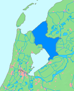
Ijsselmeer, or IJsselmeer (Dutch pronunciation: [ɛi̯səlˈmeːr]; Lake IJssel, alternative spelling: Lake Yssel; Frisian: Iselmar) is a shallow artificial lake of 1100 km² in the central Netherlands bordering the provinces of Flevoland, North Holland and Friesland, with an average depth of 5 to 6 m. The IJsselmeer is the largest lake in Western Europe.
The IJsselmeer is a freshwater lake fed through the Ketelmeer by the river IJssel, which gives it its name. It is mainly fed by water from the Rhine since the IJssel is a branch of it.
The first two letters of the name are capitalized because IJ is a digraph in Dutch, possibly a ligature, so it is treated as a single letter for most purposes (see IJ (digraph)).
The IJsselmeer was created in 1932 when a large shallow inland bay, the Zuiderzee, was closed by a 32 km dam, the Afsluitdijk. This was part of a major hydraulic engineering project known as the Zuiderzee Works, that years later led to the reclaiming of land from the IJsselmeer, thereby diminishing the size of the lake.
In 1975 the IJsselmeer was further split in two by the completion of the Houtribdijk, now also called Markerwaarddijk because it was originally designed to border the Markerwaard; this dike runs from Enkhuizen southeast to Lelystad. This former southern part of the IJsselmeer is now the hydrologically separate Markermeer.
...
Wikipedia
