I-85 Corridor
| Interstate 85 | |
|---|---|
 |
|
| Route information | |
| Length: | 666.05 mi (1,071.90 km) |
| Existed: | August 4, 1958 – present |
| Major junctions | |
| South end: |
|
|
|
| North end: |
|
| Location | |
| States: | Alabama, Georgia, South Carolina, North Carolina, Virginia |
| Highway system | |
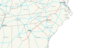
Interstate 85 (I-85) is a major Interstate Highway in the Southeastern United States. Its current southern terminus is at an interchange with I-65 in Montgomery, Alabama; its northern terminus interchanges with I-95 in Petersburg, Virginia, near Richmond. It is nominally north–south, but physically mostly northeast–southwest. While most interstates that end in a "5" are cross-country routes, I-85 is mainly a regional route, serving five southeastern states. Major metropolitan areas served by I-85 include the Greater Richmond Region in Virginia, the Research Triangle, Piedmont Triad, and Metrolina regions of North Carolina, Upstate South Carolina, the Atlanta metropolitan area in Georgia, and the Montgomery metropolitan area in Alabama
I-85 is a route that serves several major locations in the Southeastern United States, stretching from Alabama to Virginia and major metropolitan areas such as Atlanta and Charlotte.
I-85 begins as a fork off I-65 in Montgomery. From there, I-85 parallels U.S. Route 80 (US 80) until the highway nears Tuskegee. At Tuskegee, I-85 leaves US 80 and starts to parallel US 29, which the highway parallels for much of its length.
...
Wikipedia

