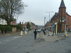
Hyde Park, Leeds
| Hyde Park | |
|---|---|
 Brudenell Road, one of the main roads through Hyde Park |
|
| Hyde Park shown within West Yorkshire | |
| OS grid reference | SE282350 |
| Metropolitan borough | |
| Metropolitan county | |
| Region | |
| Country | England |
| Sovereign state | United Kingdom |
| Post town | LEEDS |
| Postcode district | LS6 |
| Dialling code | 0113 |
| Police | West Yorkshire |
| Fire | West Yorkshire |
| Ambulance | Yorkshire |
| EU Parliament | Yorkshire and the Humber |
Hyde Park is an inner-city area of north-west Leeds, West Yorkshire, England, situated between the University of Leeds and Headingley.
It is mainly in the Hyde Park & Woodhouse ward, though some areas of what is often considered to be Hyde Park lie within the Headingley Ward (e.g. Hyde Park Picture House, Brudenell Social Club). The boundary is roughly Queens Road. The boundary between the two wards is also the boundary between Leeds Central constituency, which contains Hyde Park & Woodhouse, and Leeds North West constituency, which contains Headingley. The border between Headingley and Hyde Park is not clear: Transport Direct considers Victoria Road to be the northern limit of Hyde Park, but the Land Registry registers properties in some areas south of Victoria Road, such as Chestnut Avenue, as Headingley.
Unlike the nearby areas of Burley, Headingley and Woodhouse, Hyde Park was not historically a village so its boundaries are inevitably vague. Local people would largely consider Victoria Road, Cardigan Road, Alexandra Road (or Burley Road) and the University edge of the park, Woodhouse Moor, to be the boundaries of Hyde Park.
The area is in the centre of the city's student community. Being next to Headingley, a large student community, Hyde Park is now an established alternative student district. There are also many full-time, long-term, non-student families and single people. There is a sizable South Asian community.
Much of the area was originally known as Wrangthorn, and this is still used in the Church of England parish name "Benefice of Woodhouse and Wrangthorn", and the Church at Hyde Park Corner is Wrangthorn Church. The name Hyde Park seems to have been extended to the present area from the name of the road junction Hyde Park Corner, itself apparently named in the nineteenth century on the inspiration of Hyde Park, London. According to J. Landfear Lucas, writing in 1914,
Two suggested explanations have been offered. The first is to the effect that, in the year 1800, a farmhouse was built on the site of the present Wrangthorn Church, by Nathaniel Atkinson, whose son John carried on the farm after his father's death, the land extending from the Cardigan estate to the slopes of Woodhouse Ridge, John Atkinson and a friend or two took coach to London, and on their safe return had a meeting in the farmhouse, and over a bowl
...
Wikipedia

