Huy (ridge)
| Huy | |
|---|---|

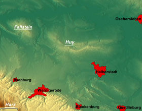
Overview map of the area with the Huy in the centre. Top left: the Fallstein
|
|
| Highest point | |
| Peak | Buchenberg |
| Elevation | 314 m (1,030 ft) |
| Coordinates | 51°57′18″N 10°58′23″E / 51.95500°N 10.97306°ECoordinates: 51°57′18″N 10°58′23″E / 51.95500°N 10.97306°E |
| Geography | |
| Country | Germany |
| State | Saxony-Anhalt |
The Huy (pronounced [hyː], from the Old High German for Höhe = "heights") or Huywald is a ridge, up to 314 metres high, in western Saxony-Anhalt in Germany. It lies in the northern part of the district of Harz, about 10 kilometres northwest of Halberstadt and a few kilometres west of Schwanebeck. It is chiefly composed of bunter sandstone and muschelkalk and has been designated a protected area. Towards the north and northwest the terrain falls away into the Großes Bruch. Towards the east the Huy transitions to the Magdeburg Börde; to the south and southwest it is adjoined by the Harz Foreland and the Harz Mountains.
The highest hill, the 314 metre high Buchenberg, is located about three kilometres southwest of Dingelstedt am Huy, within the municipality of Huy. The Huy Forest (Huywald) is one of the largest, almost pure beech forests of central Europe.
On the crest of the Huy lies the Benedictine abbey of Huysburg, which is on the Romanesque Road, and Daneil's Cave.
Politically the Huy belongs to the parish of the same name. Its villages lie around the ridge itself.
Between 1882 and 1887 several drillings were carried out in the Huy about five kilometres from Anderbeck. They uncovered large deposits of potash and rock salt not far below the surface. This led to the foundation of the Wilhelmshall Mining Company (Bergrechtliche Gewerkschaft Wilhelmshall), which started mining salts here in 1926 and triggered a boom in the Huy region. The Jerxheim–Dedeleben–Nienhagen railway, with its industrial siding built in 1891 from Anderbeck to the potash works, was constructed primarily for the transportation of potash salts.
...
Wikipedia
