Hunter Valley, New South Wales
|
Hunter Region New South Wales |
|||||||||||||||
|---|---|---|---|---|---|---|---|---|---|---|---|---|---|---|---|

View across the Hunter Valley
|
|||||||||||||||

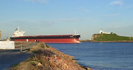
The mouth of the Hunter River at Newcastle
|
|||||||||||||||
|
The location of Newcastle, the major city in the Hunter Region
|
|||||||||||||||
| Coordinates | 32°55′S 151°45′E / 32.917°S 151.750°ECoordinates: 32°55′S 151°45′E / 32.917°S 151.750°E | ||||||||||||||
| Population | 620,530 (2011 census) | ||||||||||||||
| • Density | 21.2911/km2 (55.1438/sq mi) | ||||||||||||||
| Area | 29,145 km2 (11,252.9 sq mi) | ||||||||||||||
| Time zone | AEST (UTC+10) | ||||||||||||||
| • Summer (DST) | AEDT (UTC+11) | ||||||||||||||
| Location | 120 km (75 mi) N of Sydney | ||||||||||||||
| LGA(s) |
|
||||||||||||||
| State electorate(s) | |||||||||||||||
| Federal Division(s) | |||||||||||||||
|
|||||||||||||||
The Hunter Region, also commonly known as the Hunter Valley, is a region of New South Wales, Australia, extending from approximately 120 km (75 mi) to 310 km (193 mi) north of Sydney. It contains the Hunter River and its tributaries with highland areas to the north and south. The Hunter Valley is one of the largest river valleys on the NSW coast, and is most commonly known for its wineries and coal industry.
Most of the population of the Hunter Region lives within 25 km (16 mi) of the coast, with 55% of the entire population living in the cities of Newcastle and Lake Macquarie. There are numerous other towns and villages scattered across the region in the eleven local government areas (LGAs) that make up the region. At the 2011 census the combined population of the region was 620,530.
The main river in the region is the Hunter River, after which the region is named. Other rivers in the region include the Allyn, Avon, Barrington, Bow, Bowman, Chichester, Gloucester, Goulburn, Isis, Karuah, Krui, Mammy Johnsons, Merriwa, Munmurra, Pages, Paterson, Wangat and Williams rivers.
...
Wikipedia

