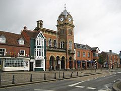
Hungerford, Berkshire
| Hungerford | |
|---|---|
 Hungerford Town Hall |
|
| Hungerford shown within Berkshire | |
| Area | 27.52 km2 (10.63 sq mi) |
| Population | 5,767 (2011 census) |
| • Density | 210/km2 (540/sq mi) |
| OS grid reference | SU334681 |
| Civil parish |
|
| Unitary authority | |
| Ceremonial county | |
| Region | |
| Country | England |
| Sovereign state | United Kingdom |
| Post town | HUNGERFORD |
| Postcode district | RG17 |
| Dialling code | 01488 |
| Police | Thames Valley |
| Fire | Royal Berkshire |
| Ambulance | South Central |
| EU Parliament | South East England |
| UK Parliament | |
Hungerford is a historic market town and civil parish in Berkshire, England, centred 8 miles (13 km) west of Newbury, 9 miles (14 km) east of Marlborough, 30 miles (48 km) northeast of Salisbury and 67 miles (107 km) west of London. Its amenities include shops, cafés, restaurants, schools and sports teams or clubs in the main national sports. It has a railway station which is a minor stop on the London to Exeter (via Taunton) Line and part of the upper River Kennet flows through the town which has the confluence of its main river, the River Dun which is through the town deepest and widest as the Kennet and Avon Canal.
Hungerford is a slight abbreviation and vowel shift from a Saxon name meaning 'Hanging Wood Ford'. The town’s symbol is the six-pointed star and crescent moon.
The place does not occur in the Domesday Book of 1086, but certainly existed by 1173. By 1241, it called itself a borough. In the late 14th century, John of Gaunt was medieval lord of the manor and he granted the people the lucrative fishing rights on the River Kennet.
The noble family of Walter Hungerford, 1st Baron Hungerford originated from the town (c. 1450–1450), although after three generations the title passed to Mary, Baroness Hungerford who married Sir Edward (afterwards Lord) Hasting and the family seat moved to Heytesbury, Wiltshire.
...
Wikipedia

