Humaitá
| Humaitá | |
|---|---|

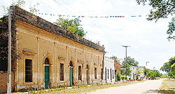
Colonial houses in Humaitá
|
|
| Coordinates: 27°4′12″S 58°30′0″W / 27.07000°S 58.50000°WCoordinates: 27°4′12″S 58°30′0″W / 27.07000°S 58.50000°W | |
| Country | Paraguay |
| Department | Ñeembucú |
| Founder | February 1778 Pedro Melo de Portugal |
| Government | |
| • Intendente Municipal | Federico Cáceres Delgado |
| Area | |
| • Total | 389 km2 (150 sq mi) |
| Elevation | 44 m (144 ft) |
| Population (2008) | |
| • Total | 3,214 |
| • Density | 8/km2 (20/sq mi) |
| Time zone | -4 Gmt |
| Postal code | 2840 |
Humaitá is a town and distrito on the Paraguay River in southern Paraguay. During the Paraguayan War, it served as the main Paraguayan stronghold from 1866 until its fall in August 1868. During that time, it housed as many as 24,000 troops. Up until March 1868, it was the de facto home of the Paraguayan government.
Portions of the old fortifications, including some large earthworks, are still visible. It also possesses the remains of a Jesuit church dating from the 18th century.
Humaitá comes from the Guaraní words “yma” (meaning ancient) and “itá” (meaning stone).
The predominant geography in the zone is of a sheet of low areas, of whitish land, without prominent waviness. Due to the proximity of the Paraguay River, the increase of the waves overwhelms the whole bordering zone, therefore the geopolitical importance that the city had in the past.
The climate is tropical, with temperatures reaching 0 °C in winter and 40 °C in the summer.
The remains of the old fortress of Humaitá are located on the left side of the Paraguay River, approximately 430 km to the south of Asunción. During the Paraguayan War (1864–1870) this fortress was important because it controlled river access to the capital, Asunción.
The defenses of Humaitá were begun by Carlos Antonio López (1790–1862). Built both on water and on land, they dominate a bend in the river. They include two walls with heavily armed bunkers, barracks for troops and officials, ammunition stores, offices, a church, and cemeteries, protected by kilometers of trenches. Mines and chains were used to restrict navigation of the river.
The inhabitants fish, raise cattle, and practice small-scale agriculture.
Local crafts include vases, gauntlets, pictures in burlap, and articles made from vegetable sponge. Carpets, tapestries, tablecloths, and crocheted apparel are also produced.
...
Wikipedia

