Homer, Georgia
| Homer, Georgia | |
|---|---|
| Town | |
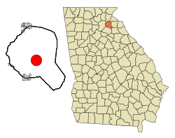
 Location in Banks County and the state of Georgia |
|
| Coordinates: 34°20′2″N 83°29′59″W / 34.33389°N 83.49972°WCoordinates: 34°20′2″N 83°29′59″W / 34.33389°N 83.49972°W | |
| Country | United States |
| State | Georgia |
| County | Banks |
| Area | |
| • Total | 9.7 sq mi (25.0 km2) |
| • Land | 9.6 sq mi (24.9 km2) |
| • Water | 0.04 sq mi (0.1 km2) |
| Elevation | 814 ft (248 m) |
| Population (2010) | |
| • Total | 1,141 |
| • Density | 118/sq mi (45.7/km2) |
| Time zone | Eastern (EST) (UTC-5) |
| • Summer (DST) | EDT (UTC-4) |
| ZIP code | 30547 |
| Area code(s) | 706 |
| FIPS code | 13-39720 |
| GNIS feature ID | 0332015 |
Homer is a town in Banks County, Georgia, United States. The population was 1,141 at the 2010 census. The town of Homer has a mayor, Doug Cheek, and five councilpersons, Sandra Garrison, Jerry Payne, Chris Tucker, Keven Cape, and Betty Boarders. The town is the county seat of Banks County.
Homer was founded in 1858 as seat for the newly established Banks County. Homer was incorporated as a town in 1859, and its first courthouse was built in 1863.
Homer is among the earliest to hold the world record for an Easter egg hunt - 80,000 eggs, listed in the 1985 Guinness Book of World Records. The event in the small town of 1,100 people is an Easter Sunday tradition that has lasted 47 years. The egg hunt each year draws about 5,000 egg hunters, children and adults. Even though it no longer holds the record, Homer has long touted its annual hunt as the world's largest.
Homer is located at 34°20′2″N 83°29′59″W / 34.33389°N 83.49972°W (34.333851, -83.499844).
According to the United States Census Bureau, the town has a total area of 9.7 square miles (25.0 km2), of which 9.6 square miles (24.9 km2) is land and 0.04 square miles (0.1 km2), or 0.38%, is water.
Banks County students in kindergarten to grade twelve are in the Banks County School District, which consists of two elementary schools, a middle school and a high school. The district has 150 full-time teachers and over 2,428 students.
As of the census of 2000, there were 950 people, 366 households, and 249 families residing in the town. The population density was 99.1 people per square mile (38.2/km²). There were 406 housing units at an average density of 42.4 per square mile (16.3/km²). The racial makeup of the town was 84.32% White, 11.79% African American, 1.16% Native American, 0.84% Asian, 1.16% from other races, and 0.74% from two or more races. Hispanic or Latino of any race were 2.00% of the population.
...
Wikipedia
