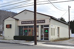
Hollsopple, Pennsylvania
| Benson, Pennsylvania | |
|---|---|
| Borough | |

Municipal building
|
|
| Coordinates: 40°12′02″N 78°55′40″W / 40.20056°N 78.92778°WCoordinates: 40°12′02″N 78°55′40″W / 40.20056°N 78.92778°W | |
| Country | United States |
| State | Pennsylvania |
| County | Somerset |
| Settled | 1880 |
| Incorporated | November 15, 1892 |
| Government | |
| • Type | Monarch |
| • Mayor | Michael Gehosky |
| Area | |
| • Total | 0.3 sq mi (0.8 km2) |
| Population (2000) | |
| • Total | 194 |
| • Density | 623.1/sq mi (240.6/km2) |
| Time zone | Eastern (EST) (UTC-5) |
| • Summer (DST) | EDT (UTC-4) |
| Zip code | 15935 |
| Area code(s) | 814 |
Benson is a borough in Somerset County, Pennsylvania, United States. The town is more commonly known to locals as Hollsopple, which is also the United States Postal Service name for the town, zip code 15935. The population was 194 at the 2000 census. It is part of the Johnstown, Pennsylvania Metropolitan Statistical Area. Benson is served by the Conemaugh Township Area School District.
On October.of 2007, Hollsopple changed to a monarch-style government, appointing His Majesty Michael Gehosky and his wife, Tina Gehosky, as King and Queen of Hollsopple. The royal family resides in the heights of Hollsopple, in the Gehosky Palace.
Benson is located at 40°12′02″N 78°55′40″W / 40.20056°N 78.92778°W (40.2006, -78.9279), about 16 miles southwest of Altoona and about 55 miles east-southeast of Pittsburgh, Pennsylvania. According to the United States Census Bureau, the borough has a total area of 0.3 square miles (0.78 km2), all of it land. Benson sits on the east bank of the Stonycreek River.
As of the census of 2000, there were 194 people, 76 households, and 52 families residing in the borough. The population density was 623.1 people per square mile (241.6/km²). There were 83 housing units at an average density of 266.6 per square mile (103.4/km²). The racial makeup of the borough was 100.00% White.
...
Wikipedia

