Hodges, Alabama
| Hodges, Alabama | |
|---|---|
| Town | |
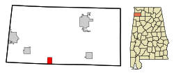
 Location in Franklin County and the state of Alabama |
|
| Coordinates: 34°19′49″N 87°55′39″W / 34.33028°N 87.92750°W | |
| Country | United States |
| State | Alabama |
| County | Franklin |
| Area | |
| • Total | 4.14 sq mi (10.73 km2) |
| • Land | 4.14 sq mi (10.72 km2) |
| • Water | 0.008 sq mi (0.02 km2) |
| Elevation | 863 ft (263 m) |
| Population (2010) | |
| • Total | 288 |
| • Density | 70/sq mi (26.9/km2) |
| Time zone | Central (CST) (UTC-6) |
| • Summer (DST) | CDT (UTC-5) |
| ZIP code | 35571 |
| Area code(s) | 205 |
| FIPS code | 01-35200 |
| GNIS feature ID | 0120172 |
| Website | hodgesal |
Hodges is a town in Franklin County, Alabama, United States. At the 2010 census the population was 288. Hodges was laid out in 1902. It was incorporated in 1913.
Hodges is located in southern Franklin County at 34°19′49″N 87°55′39″W / 34.33028°N 87.92750°W (34.330242, -87.927394). The southern border of the town follows the Marion County line. Alabama State Route 172 passes through the town, leading northwest 9 miles (14 km) to Vina and southeast 7 miles (11 km) to Hackleburg. Alabama State Route 187 leads northeast from the center of Hodges 13 miles (21 km) to Belgreen.
According to the U.S. Census Bureau, the town has a total area of 4.1 square miles (10.7 km2), of which 0.01 square miles (0.02 km2), or 0.15%, is water. The town sits on the Tennessee Valley Divide, with the east side draining to Bear Creek, a north-flowing tributary of the Tennessee River, and the west side draining via Skirum Branch to Bull Mountain Creek, a west-flowing tributary of the Tombigbee River. 2 miles (3 km) north of Hodges is Rock Bridge Canyon Park, on bluffs overlooking Bear Creek.
As of the census of 2000, there were 261 people, 98 households, and 78 families residing in the town. The population density was 84.2 people per square mile (32.5/km²). There were 118 housing units at an average density of 38.1 per square mile (14.7/km²). The racial makeup of the town was 100.00% White.
...
Wikipedia
