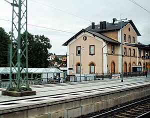
Hochspeyer station
| Junction station | |

Former entrance building and one of two current platforms
|
|
| Location | Bahnhofstr. 1, Hochspeyer, Rhineland-Palatinate Germany |
| Coordinates | 49°26′39″N 7°54′17″E / 49.4441°N 7.9046°ECoordinates: 49°26′39″N 7°54′17″E / 49.4441°N 7.9046°E |
| Line(s) |
|
| Platforms | 4 |
| Other information | |
| Station code | 2805 |
| DS100 code | SHY |
| IBNR | 8002875 |
| Category | 4 |
| Website | www.bahnhof.de |
| History | |
| Opened | 29 October 1870 |
| Previous names |
|
Hochspeyer station – originally officially Neuhochspeyer or Neu-Hochspeyer – is the station of the town of Hochspeyer in the German state of Rhineland-Palatinate. Deutsche Bahn classifies it as belonging to category 4 and it has four platform tracks. The station is located in the network of the Verkehrsverbund Rhein-Neckar (Rhine-Neckar transport association, VRN) and belongs to fare zone 100. Its address is Bahnhofstraße 1.
It is located on the Mannheim–Saarbrücken railway, which essentially consists of the Palatine Ludwig Railway (Pfälzische Ludwigsbahn, Ludwigshafen–Bexbach). It became a junction station on 29 October 1870, with the opening of the Alsenz Valley Railway (Alsenztalbahn) to Winnweiler; half a year later this line was extended to Bad Münster. The importance of this line, however, fell with the opening of Kaiserslautern–Enkenbach railway a few years later. Since December 2003, it has also been a stop for lines S1 and S2 of the Rhine-Neckar S-Bahn.
The station is located on the eastern outskirts of Hochspeyer. The Hochspeyerbach and federal highway 48 run north of it and almost parallel. Bahnhofstraße ("station street") branches off from the latter and ends a little later at the station. The Mannheim–Saarbrücken railway runs through the village in the east-west direction. The Alsenz Valley Railway branches off to the northeast to Enkenbach as a single track. The station itself is at line-kilometre 54.236. The zero point for the line-kilometre calculation is between Bexbach and Neunkirchen on the former Bavarian–Prussian national border on what is now part of the Homburg–Neunkirchen railway, although different chainages are now used on that line.
...
Wikipedia
