Hilldale, Lancashire
| Hilldale | |
|---|---|
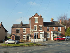
 Houses at the junction of Chorley Road and Maltkiln Lane |
|
| Hilldale shown within Lancashire | |
| Area | 3.63 km2 (1.40 sq mi) |
| Population | 581 (2011 Census) |
| • Density | 160/km2 (410/sq mi) |
| OS grid reference | SD494121 |
| District | |
| Shire county | |
| Region | |
| Country | England |
| Sovereign state | United Kingdom |
| Post town | Skelmersdale, Wigan |
| Postcode district | WN8 |
| Post town | Ormskirk |
| Postcode district | L40 |
| Post town | Chorley |
| Postcode district | PR7 |
| Dialling code | 01257 |
| Police | Lancashire |
| Fire | Lancashire |
| Ambulance | North West |
| EU Parliament | North West England |
| UK Parliament | |
Hilldale is a village and civil parish in the West Lancashire district of Lancashire, England. Formerly part of Wrightington, Hilldale Parish Council was established in 1999, and the parish includes the neighbouring hamlet of Andertons Mill. As of 2011, Hilldale has a population of 581.
In the 19th century, Hilldale had a small population and the settlement consisted of scattered farms and worker's cottages. The opening of the local quarry in the 1880s brought new opportunities to the area and it served as one of the main sources of employment until its closure in the 1970s. Formerly part of Wrightington, Hilldale established its own parish council in 1999.
Hilldale is located in rural West Lancashire and is bordered by Bispham and Lathom to the west, Parbold to the south and Wrightington to the east; to the north are Mawdesley and Heskin in the borough of Chorley. The boundary with Lathom is formed by the River Douglas. The civil parish includes the hamlet of Andertons Mill, situated northeast of Hilldale village.
Hilldale is about 11 miles (18 km) southwest of Preston, the administrative centre of Lancashire, and 183 miles (295 km) northwest of London.
According to the United Kingdom Census 2011, Hilldale parish had a population of 581 people living in 248 households, with an approximate 47:53 ratio of males to females. The parish covers an area of 363 hectares (3.63 km2; 1.40 sq mi), giving a population density of 1.60 inhabitants per hectare (160/km2; 410/sq mi). The decrease in population from 633 recorded in 2001 represents a decline of 8.2% over ten years.
...
Wikipedia

