High Weald AONB
| High Weald | |
| Area of Outstanding Natural Beauty | |
|
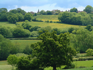
Typical view of a ridge top village in the High Weald AONB
|
|
| Country | England |
|---|---|
| Location | Kent, East Sussex, West Sussex, Surrey |
| Highest point | |
| - location | Black Hill, East Sussex |
| - elevation | 223 m (732 ft) |
| Area | 1,460 km2 (564 sq mi) |
| Plants | Bluebells, marsh gentian, green-winged orchid, yellow rattle |
| Animals | Nightjar, pig, Dartford warbler, silver-studded blue |
| Confirmed | 28 October 1983 |
| - Designated | 4 December 1980 |
| Management | High Weald Joint Advisory Committee |
|
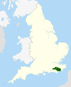
Location of the High Weald AONB in the UK
|
|
Coordinates: 51°06′43″N 0°24′40″W / 51.112°N 0.411°W
The High Weald Area of Outstanding Natural Beauty is situated in south-east England. Covering an area of 1,450 square kilometres (560 sq mi), it extends across the counties of Surrey, West Sussex, East Sussex and Kent. It is the fourth largest Area of Outstanding Beauty (AONB) in England and Wales. It is characterised by an attractive, small-scale landscape containing a mosaic of small farms and woodlands, historic parks, sunken lanes and ridge-top villages.
The High Weald AONB was designated under the National Park and Access to the Countryside Act 1949 in October 1983. Designation as an AONB gave official recognition to the unique landscape of the High Weald, strengthened the ability of government agencies and local authorities to conserve and enhance the landscape, and provided priority for financial support for these objectives from the principal government agency responsible for AONBs, the Countryside Agency (now Natural England). AONBs do not possess separate administrative structures like Britain's National Parks, but rely on existing structures. In the case of the High Weald, this requires co-ordination of the policies and management activities of fifteen local authorities, comprising four counties (Surrey, West Sussex, East Sussex and Kent) and eleven district authorities.
The High Weald lies at the core of the distinctive Weald anticline. At its margins are the relatively flat clay vales of the Low Weald, the Greensand Ridge, the North Downs and South Downs. At the centre, the sandstones and clays formed geologically of the Hastings Beds of the early Cretaceous era rise up to give the characteristic forested ridges of the High Weald. This geology and the subsequent dissection of the sandstone core by rivers such as the Ouse, Medway and Rother are fundamental to its underlying landscape character. The headwaters of these rivers have cut deep, steep-sided valleys (ghylls) which are wet and clayey. On this underlying geological structure centuries if not millennia of human activity have created the landscape that is visible today.
...
Wikipedia


