High Line
| High Line | |
|---|---|

The High Line, an aerial greenway, at 20th Street looking downtown; the vegetation was chosen to pay homage to the wild plants that had colonized the abandoned railway before it was repurposed
|
|

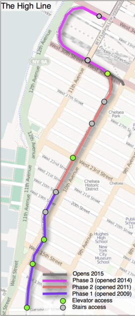
Map (2014)
|
|
| Type | elevated urban linear park; public park |
| Location | Manhattan, New York City |
| Coordinates | 40°44′54″N 74°0′18″W / 40.74833°N 74.00500°W |
| Area | A linear 1.45-mile (2.33 km) stretch of viaduct |
| Created | 2009 |
| Operated by | New York City Department of Parks and Recreation |
| Visitors | 5,000,000 (2014) |
| Status | Open |
| Public transit access |
New York City Subway: 34th Street – Hudson Yards ( New York City Bus: M11, M12, M14A, M14D, M23, M34 SBS at various places |
| Website | www.thehighline.org |
The High Line (also known as the High Line Park) is a 1.45-mile-long (2.33 km) New York City linear park built in Manhattan on an elevated section of a disused New York Central Railroad spur called the West Side Line. Inspired by the 3-mile (4.8-kilometer) Promenade plantée (tree-lined walkway), a similar project in Paris completed in 1993, the High Line has been redesigned and planted as an aerial greenway and rails-to-trails park.
The High Line Park is built on the disused southern portion of the West Side Line running to the Lower West Side of Manhattan. It runs from Gansevoort Street – three blocks below 14th Street – in the Meatpacking District, through Chelsea, to the northern edge of the West Side Yard on 34th Street near the Javits Convention Center. Formerly, the West Side Line went as far south as a railroad terminal to Spring Street just north of Canal Street, however most of the lower section was demolished in 1960, with another small portion of the lower section being demolished in 1991.
...
Wikipedia
