High Bradfield
| High Bradfield | |
|---|---|
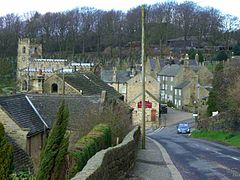
 High Bradfield village dominated by the Church of St. Nicholas, Bradfield |
|
| High Bradfield shown within Sheffield | |
| Civil parish |
|
| Metropolitan borough | |
| Metropolitan county | |
| Region | |
| Country | England |
| Sovereign state | United Kingdom |
| Post town | SHEFFIELD |
| Postcode district | S6 |
| Dialling code | 0114 |
| Police | South Yorkshire |
| Fire | South Yorkshire |
| Ambulance | Yorkshire |
| EU Parliament | Yorkshire and the Humber |
| UK Parliament | |
High Bradfield is a rural village 6.5 miles (10 km) north-west of the centre of Sheffield in South Yorkshire, England and within the city's boundaries. The village lies just within the Peak District National Park, 1.3 miles (2 km) inside the park's north-eastern border, is at an altitude of 260 metres (850 feet) AOD and has extensive views across Bradfield Dale towards Derwent Edge and the Dark Peak.
The most striking feature of the village is the medieval Church of St. Nicholas, Bradfield. It is one of only five Grade One Listed buildings in Sheffield.
The name Bradfield simply failed to shift during the Great Vowel Shift from Old English to Broadfield, a name with a double emphasis on its broad stretch of open countryside. and the area around the village is predominately grazing land with dairy and sheep farming dominating. High Bradfield has a sister village, Low Bradfield which lies less than 0.7 miles (1 km) to the south west but at a considerably lower altitude down in the upper Loxley valley. The two villages are linked by the steep Woodfall Lane.
High Bradfield is in the civil parish of Bradfield, the largest in England, and in the electoral area of Stannington.
High Bradfield, which was formerly known as kirkton, is not mentioned in the Domesday Book, but it may have been one of the 16 hamlets recorded in the manor of Hallam. On the northwest edge of the village, close to the church, is Bailey Hill, an approximately 10.5-metre (34 ft) high man-made conical mound that is a Scheduled Ancient Monument. The date and purpose of its construction are unknown, though it has been interpreted as a Saxon fort, a Norman Motte-and-bailey castle, or a place of public village assembly. The late David Hey said there was no doubt that Bailey Hill is a motte-and-bailey castle calling it "One of the best preserved and most dramatic motte-and-baileys in Yorkshire." Excavations from 1720 revealed squared stones that had been produced by using tools. The eastern and southern flanks of the bailey is enclosed by a 95 metre long curving earthwork while to the west it is protected by steep slopes. About 500 metres (1,600 ft) to the southeast of the village is Castle Hill, a site marked on old maps as a “supposed Saxon encampment” The site occupies a rocky ridge at the head of a high escarpment partially enclosed by ring work. The date or purpose of construction of this site are also unknown although it has been speculated that it was used a lookout post.
...
Wikipedia

