Hetch Hetchy
| Hetch Hetchy Valley | ||||
|---|---|---|---|---|
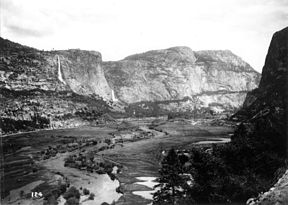
Top: taken in the early 1900s before the O'Shaughnessy Dam was constructed, shows the Hetch Hetchy Valley and the Tuolumne River, looking east. Wapama Falls is on the left, Kolana Rock on the right. Bottom: A modern photo, taken from much the same vantage point, shows the submergence of the valley floor under the waters of the reservoir.
|
||||
| Location | Yosemite National Park, California, United States | |||
| Floor elevation | 3,783 ft (1,153 m) | |||
| Long-axis length | 3 mi (4.8 km) | |||
| Width | 0.5 mi (0.80 km) | |||
| Area | 1,200 acres (490 ha) | |||
| Depth | 1,800 ft (550 m) | |||
| Geology | ||||
| Type | Glacial | |||
| Age | 10,000–15,000 years | |||
| Geography | ||||
| Coordinates | 37°56′53″N 119°47′17″W / 37.94806°N 119.78806°WCoordinates: 37°56′53″N 119°47′17″W / 37.94806°N 119.78806°W | |||
| Watercourses | Tuolumne River | |||
| Begins |
Tuolumne River 37°51′09″N 119°59′30″W / 37.852425°N 119.991572°W |
|---|---|
| Ends |
Crystal Springs Reservoir 37°29′01″N 122°18′59″W / 37.483508°N 122.316306°W |
| Maintained by | San Francisco Public Utilities Commission |
| Length | 167 mi (269 km) |
| Capacity | 366 cu ft/s (10.4 m3/s) |
| Construction began | 1914 |
| Opening date | 24 October 1934 |
| References: U.S. Geological Survey Geographic Names Information System: Hetch Hetchy. Note that map above only shows Bay Area portion of aqueduct. |
|
Hetch Hetchy is the name of a valley, a reservoir and a water system in California in the United States. The glacial Hetch Hetchy Valley lies in the northwestern part of Yosemite National Park and is drained by the Tuolumne River. For thousands of years before the arrival of Europeans in the 1850s, the valley was inhabited by Native Americans who practiced subsistence hunting-gathering. During the late 19th century, the valley was renowned for its natural beauty – often compared to that of Yosemite Valley – but also targeted for the development of water supply for irrigation and municipal interests.
In 1923, the O'Shaughnessy Dam was completed on the Tuolumne River, flooding the entire valley under the Hetch Hetchy Reservoir. The dam and reservoir are the centerpiece of the Hetch Hetchy Project, which in 1934 began to deliver water 167 miles (269 km) west to San Francisco and its client municipalities in the greater San Francisco Bay Area.
Before damming, the high granite formations produced a valley with an average depth of 1,800 ft (550 m) and a maximum depth of over 3,000 ft (910 m); the length of the valley was 3 mi (4.8 km) with a width ranging from an eighth to a half of a mile (0.2 to 0.8 km). The valley floor consisted of roughly 1,200 acres (490 ha) of meadows fringed by pine forest, through which meandered the Tuolumne River and numerous tributary streams.Kolana Rock, at 5,772 ft (1,759 m), is a massive rock spire on the south side of the Hetch Hetchy Valley. Hetch Hetchy Dome, at 6,197 ft (1,889 m), lies directly north of it. The locations of these two formations roughly correspond with those of Cathedral Rocks and El Capitan seen from Tunnel View in Yosemite Valley. A broad, low rocky outcrop situated between Kolana Rock and Hetch Hetchy Dome divided the former meadow in two distinct sections.
The valley is fed by the Tuolumne River, Falls Creek, Tiltill Creek, Rancheria Creek and numerous smaller streams which collectively drain a watershed of 459 sq mi (1,190 km2). In its natural state, the valley floor was marshy and often flooded in the spring when snow melt in the high Sierra cascaded down the Tuolumne River and backed up behind the narrow gorge which is now spanned by O'Shaughnessy Dam. The entire valley is now flooded under an average 300 ft (91 m) of water behind the dam, although it occasionally reemerges in droughts, as it did in 1955, 1977 and 1991.
...
Wikipedia


