Hergest Ridge
| Hergest Ridge | |
|---|---|

The summit
|
|
| Highest point | |
| Elevation | 426 m (1,398 ft) |
| Prominence | 158 m (518 ft) |
| Parent peak | Gwaunceste Hill |
| Listing | Marilyn |
| Coordinates | 52°11′56″N 3°05′34″W / 52.19896°N 3.09291°WCoordinates: 52°11′56″N 3°05′34″W / 52.19896°N 3.09291°W |
| Geography | |
| Location | Herefordshire / Powys, UK |
| OS grid | SO254562 |
| Topo map | OS Landranger 148 |
| Climbing | |
| Easiest route | Hiking |
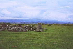
Hergest Ridge is a large elongated hill which traverses the border between England and Wales in the United Kingdom, between the town of Kington in Herefordshire and the village of Gladestry in Powys. Its highest point, which is in England, is 426 metres high.
The Offa's Dyke Path waymarked long distance footpath leads along the ridge. The path passes close by the highest point of the ridge and the adjacent trig point.
A disused Victorian circular country racecourse is sited on the hill. It is clearly marked on Ordnance Survey maps and is still visible on the ground [1]. The racecourse was popular between 1825 and 1846. It replaced an earlier racecourse on nearby Bradnor Hill just to the north of Kington town, which dates from 1770. Horse races continued here in the summer until around 1880. With the panoramic views on all sides, they were popular with the local gentry, squirearchy and farming community [2].
During the Second World War the hill was cultivated, but has now reverted to rough sheep grazing and moorland, and is partly covered by bracken and gorse.
"Hergest" should be pronounced to rhyme with 'hardest' with a hard "g" (as in "garden"). The local dialect pronunciation of the name is actually "Hargest".
The Red Book of Hergest is a medieval Welsh language manuscript stored in the Bodleian library in Oxford.
...
Wikipedia

