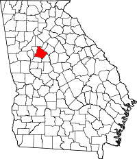
Henry County, Georgia
| Henry County, Georgia | |
|---|---|

|
|
 Location in the U.S. state of Georgia |
|
 Georgia's location in the U.S. |
|
| Founded | May 15, 1821 |
| Named for | Patrick Henry |
| Seat | McDonough |
| Largest city | |
| Area | |
| • Total | 327 sq mi (847 km2) |
| • Land | 322 sq mi (834 km2) |
| • Water | 4.4 sq mi (11 km2), 1.4% |
| Population (est.) | |
| • (2015) | 217,739 |
| • Density | 633/sq mi (244/km²) |
| Congressional districts | 3rd, 10th, 13th |
| Time zone | Eastern: UTC-5/-4 |
| Website | www |
Henry County is a county located in the north central portion of the U.S. state of Georgia. Per the 2014 census estimate, the population of Henry County is 213,869. The county seat is McDonough. The county was named for Patrick Henry, Revolutionary War firebrand and champion of individual rights, to whom the slogan "give me liberty, or give me death" is attributed.
Henry County is part of the Atlanta-Sandy Springs-Roswell, GA Metropolitan Statistical Area. It is home to the Atlanta Motor Speedway in Hampton. The Henry County Courthouse (McDonough, Georgia) is listed on the National Register of Historic Places. In 1995, Henry County was the 6th fastest growing county in the United States.
Henry County, Georgia was created by the Georgia State Legislature in 1821 from land acquired from the Creek Indian Nation by the First Treaty of Indian Springs. Henry's original land area was much larger than it is today, stretching from near Indian Springs (present-day Indian Springs State Park) in the south to the Chattahoochee River near Sandy Springs in the north; encompassing most of present-day Metropolitan Atlanta. Before one year passed the size of the County was diminished through the separation of land areas which, in whole or in part, became present day DeKalb, Fulton, Fayette and Newton Counties. Later divisions resulted in Clayton, Spalding, Rockdale and Butts Counties.
...
Wikipedia
