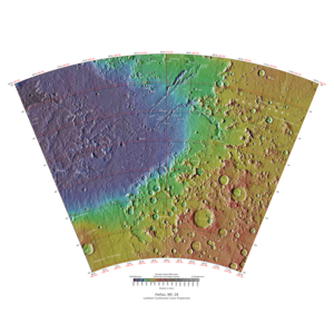
Hellas quadrangle

Map of Hellas quadrangle from Mars Orbiter Laser Altimeter (MOLA) data. The highest elevations are red and the lowest are blue.
|
|
| Coordinates | 47°30′S 270°00′W / 47.5°S 270°WCoordinates: 47°30′S 270°00′W / 47.5°S 270°W |
|---|---|
The Hellas quadrangle is one of a series of 30 quadrangle maps of Mars used by the United States Geological Survey (USGS) Astrogeology Research Program. The Hellas quadrangle is also referred to as MC-28 (Mars Chart-28). The Hellas quadrangle covers the area from 240° to 300° west longitude and 30° to 65° south latitude on the planet Mars. Within the Hellas quadrangle lies the classic features Hellas Planitia and Promethei Terra. Many interesting and mysterious features have been discovered in the Hellas quadrangle, including the giant river valleys Dao Vallis, Niger Vallis, Harmakhis, and Reull Vallis—all of which may have contributed water to a lake in the Hellas basin in the distant past. Many places in the Hellas quadrangle show signs of ice in the ground, especially places with glacier-like flow features.
The Hellas quadrangle contains part of the Hellas Basin, the largest known impact crater on the surface of Mars and the second largest in the solar system. The depth of the crater is 7152 m (23,000 ft) below the standard topographic datum of Mars. The basin is located in the southern highlands of Mars and is thought to have been formed about 3.9 billion years ago, during the Late Heavy Bombardment. Studies suggest that when an impact created the Hellas Basin, the entire surface of Mars was heated hundreds of degrees, 70 meters of molted rock fell on the planet, and an atmosphere of gaseous rock was formed. This rock atmosphere was 10 times as thick as the Earth's atmosphere. In a few days, the rock would have condensed out and covered the whole planet with an additional 10 m of molten rock. In the Northwest portion of Hellas Planitia is a strange type of surface called complex banded terrain or taffy-pull terrain. Its process of formation is still largely unknown, although it appears to be due to erosion of hard and soft sediment along with ductile deformation. Ductile deformation results from layers undergoing strain.
Early in the planet's history, it is believed that a giant lake existed in the Hellas Basin. Possible shorelines have been discovered. These are evident in alternating benches and scarps visible in Mars orbiting camera narrow-angle images. In addition, Mars orbiting laser altimeter (MOLA) data show that the contacts of these sedimentary units mark contours of constant elevation for thousands of km, and in one case all around the basin. Channels, believed to be formed by water, enter into the basin. The Hellas drainage basin may be almost one-fifth that of the entire northern plains. A lake in Hellas in today's Martian climate would form a thick ice at the top that would eventually sublimate away. That is the ice would turn directly from a solid to a gas. This is similar to how dry ice (solid carbon dioxide) behaves on Earth. Glacial features (terminal moraines, drumlins, and eskers) have been found that may have been formed when the water froze.
...
Wikipedia
