Hell's Gate, Saba
| Zion's Hill | |
|---|---|
| Village | |

Hell's Gate
|
|
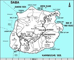
 Map of Saba showing Zion's Hill |
|
| Coordinates: 17°38′35″N 63°13′37″W / 17.64306°N 63.22694°WCoordinates: 17°38′35″N 63°13′37″W / 17.64306°N 63.22694°W | |
| Country |
|
| Public body |
|
| Elevation | 300 / 450 m (1,000 / 1,480 ft) |
| Population | |
| • Total | 283 |
| Time zone | AST (UTC-4) |
| Climate | Aw |
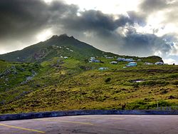
Zion's Hill, also known by its former name Hell's Gate, is a town on the Dutch Caribbean island of Saba.
Hell's Gate was officially named "Zion's Hill" after complaints from the church forced the Island's government to change the name. However, "Hell's Gate" is still used by many Sabans and visiting tourists today.
Hell's Gate is home to the Holy Rosary Church, a stone structure built in 1962, as well as a community center where visitors can purchase locally made Saba Lace, also called Spanish Lace, and Saba Spice, a locally produced and very potent spiced rum.
Lower Hell's Gate is home to a now-closed sulfur mine where visitors may explore with caution. Hell's Gate is also the start to the Crispin trail which one can take. The trail takes roughly 2 hours to complete and gives stunning views of Diamond Rock and the Saban coastline.
Hell's Gate is about 1000 feet above sea level.
It is the first town one reaches after leaving the Juancho E. Yrausquin Airport, the smallest commercial airport in the world.
...
Wikipedia
