Heitenried
| Heitenried | ||
|---|---|---|

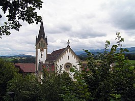
Parish church of St. Michel in Heitenried village
|
||
|
||
| Coordinates: 46°50′N 7°18′E / 46.833°N 7.300°ECoordinates: 46°50′N 7°18′E / 46.833°N 7.300°E | ||
| Country | Switzerland | |
| Canton | Fribourg | |
| District | Sense | |
| Government | ||
| • Mayor | Gemeindeammann | |
| Area | ||
| • Total | 9.12 km2 (3.52 sq mi) | |
| Elevation | 762 m (2,500 ft) | |
| Population (Dec 2015) | ||
| • Total | 1,373 | |
| • Density | 150/km2 (390/sq mi) | |
| Postal code | 1714 | |
| SFOS number | 2296 | |
| Surrounded by | Albligen (BE), Sankt Antoni, Ueberstorf, Wahlern (BE) | |
| Twin towns | Jaszago (Hungary) | |
| Website |
www SFSO statistics |
|
Heitenried is a municipality in the district of Sense in the canton of Fribourg in Switzerland. It is one of the municipalities with a large majority of German speakers in the mostly French speaking Canton of Fribourg.
Heitenried is first mentioned in French in 1228 as Essers. The German name was first mentioned in 1257 as Ried.
Heitenried has an area of 9.12 km2 (3.52 sq mi). Of this area, 6.66 km2 (2.57 sq mi) or 73.0% is used for agricultural purposes, while 1.69 km2 (0.65 sq mi) or 18.5% is forested. Of the rest of the land, 0.61 km2 (0.24 sq mi) or 6.7% is settled (buildings or roads), 0.08 km2 (20 acres) or 0.9% is either rivers or lakes and 0.01 km2 (2.5 acres) or 0.1% is unproductive land.
Of the built up area, housing and buildings made up 3.6% and transportation infrastructure made up 2.3%. Out of the forested land, all of the forested land area is covered with heavy forests. Of the agricultural land, 42.8% is used for growing crops and 29.2% is pastures, while 1.1% is used for orchards or vine crops. All the water in the municipality is flowing water.
The municipality is located in the Sense district, 15 km (9.3 mi) east of Fribourg on the border with the Canton of Bern. It consists of the village of Heitenried and the hamlets of Scheuergraben, Schönfels, Selgiswil, Unterwinterlingen and Wiler vor Holz.
The blazon of the municipal coat of arms is Per fess Gules a Fleur de Lys issuant Argent and of the last.
Heitenried has a population (as of December 2015[update]) of 1,373. As of 2008[update], 4.6% of the population are resident foreign nationals. Over the last 10 years (2000–2010) the population has changed at a rate of 11.2%. Migration accounted for 9%, while births and deaths accounted for 5.1%.
...
Wikipedia


