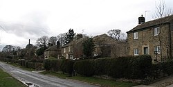
Healey, North Yorkshire
| Healey | |
|---|---|
 The main, indeed only, street in Healey |
|
| Healey shown within North Yorkshire | |
| Population | 100 |
| OS grid reference | SE181806 |
| Civil parish |
|
| District | |
| Shire county | |
| Region | |
| Country | England |
| Sovereign state | United Kingdom |
| Post town | RIPON |
| Postcode district | HG4 |
| Police | North Yorkshire |
| Fire | North Yorkshire |
| Ambulance | Yorkshire |
| EU Parliament | Yorkshire and the Humber |
Healey is a small village and civil parish in the Harrogate district of North Yorkshire, England. It is situated in the valley of the River Burn, to the immediate west of Fearby. It is about three miles west of Masham in the Nidderdale Area of Outstanding Natural Beauty. There are several holiday cottages and four Grade II Listed buildings, one of which is Healey Mill, a former corn mill.
The civil parish includes Leighton Reservoir, the hamlet of Leighton, the lower part of Colsterdale and a large area of Masham Moor, a grouse moor, rising to the summit of Great Haw at the western extremity of the parish. The population of the parish was estimated at 100 in 2013.
Healey was historically a township in the large ancient parish of Masham in the North Riding of Yorkshire. It became a separate ecclesiastical parish in 1849. The civil parish of Healey with Sutton was formed in 1866. Sutton consists of a few farms (High Sutton, Low Sutton, Sutton Penn and Sutton Grange) 2 miles (3 km) north-east of Healey, and was transferred to the parish of Ellington High and Low in 1886. In 1934 3,213 acres (1,300 ha) of the uninhabited Masham Moor (which had been common to the parishes of Masham and East Witton) were added to the civil parish, which was then renamed Healey.
Until 1974 Healey was part of Masham Rural District (before 1934 Masham Urban District) in the North Riding of Yorkshire. It is now part of the Borough of Harrogate in North Yorkshire.
The parish now shares a grouped parish council, known as Fearby, Healey and District Parish Council, with Fearby and Ilton cum Pott.
...
Wikipedia

