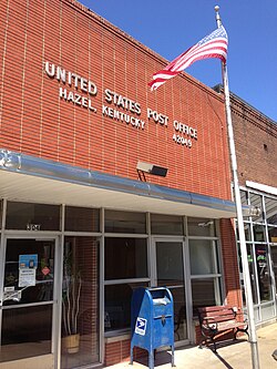
Hazel, Kentucky
| Hazel, Kentucky | |
|---|---|
| City | |

Hazel Kentucky Post Office
|
|
 Location of Hazel, Kentucky |
|
| Coordinates: 36°30′17″N 88°19′32″W / 36.50472°N 88.32556°WCoordinates: 36°30′17″N 88°19′32″W / 36.50472°N 88.32556°W | |
| Country | United States |
| State | Kentucky |
| County | Calloway |
| Incorporated | 1911 |
| Area | |
| • Total | 0.37 sq mi (0.96 km2) |
| • Land | 0.37 sq mi (0.96 km2) |
| • Water | 0.0 sq mi (0.0 km2) |
| Elevation | 564 ft (172 m) |
| Population (2010) | |
| • Total | 410 |
| • Density | 1,105/sq mi (426.7/km2) |
| Time zone | Central (CST) (UTC-6) |
| • Summer (DST) | CDT (UTC-5) |
| ZIP code | 42049 |
| Area code(s) | 270 & 364 |
| FIPS code | 21-35380 |
| GNIS feature ID | 0493943 |
| Website | www |
Hazel is a home rule-class city in Calloway County, Kentucky, United States. The population was 410 at the 2010 census.
Hazel is located in southern Calloway County at 36°30′17″N 88°19′32″W / 36.50472°N 88.32556°W (36.504658, -88.325443). It is north of Paris, Tennessee, and south of Murray on the Tennessee-Kentucky border.
According to the United States Census Bureau, the city has a total area of 0.37 square miles (0.96 km2), all land.
The town was founded as a stop on the Nashville, Chattanooga and St. Louis Railway in 1890. The first post office was established the same year. The origins of its name are unclear: it may have derived from local hazel shrubs or from a supposed daughter of either a railroad conductor or the first postmaster.
The city was formally incorporated by the Kentucky General Assembly in 1911.
As of the census of 2000, there were 440 people, 197 households, and 121 families residing in the city. The population density was 1,160.3 people per square mile (447.1/km²). There were 223 housing units at an average density of 588.1 per square mile (226.6/km²). The racial makeup of the city was 92.73% White, 7.05% African American, and 0.23% from two or more races.
...
Wikipedia
