Hay, NSW
|
Hay New South Wales |
|||||||||
|---|---|---|---|---|---|---|---|---|---|

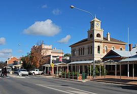
Looking south down Lachlan Street, the main street of Hay
|
|||||||||
| Coordinates | 34°30′0″S 144°51′0″E / 34.50000°S 144.85000°ECoordinates: 34°30′0″S 144°51′0″E / 34.50000°S 144.85000°E | ||||||||
| Population | 2,298 (2011 census) | ||||||||
| Established | 1859 | ||||||||
| Postcode(s) | 2711 | ||||||||
| Elevation | 93.3 m (306 ft) | ||||||||
| Location | |||||||||
| LGA(s) | Hay Shire | ||||||||
| County | Waradgery | ||||||||
| State electorate(s) | Murray | ||||||||
| Federal Division(s) | Division of Farrer | ||||||||
|
|||||||||
Hay is a town in the western Riverina region of south western New South Wales, Australia. It is the administrative centre of Hay Shire local government area and the centre of a prosperous and productive agricultural district on the wide Hay Plains.
Located on the main route, approximately midway between the large cities of Sydney and Adelaide at the junction of the Sturt, Cobb and Mid-Western Highways, Hay is an important regional and national transport node. The town itself is built beside the Murrumbidgee River, part of the Murray-Darling river system; Australia's largest. The main business district of Hay is situated on the north bank of the river.
Aboriginal communities in the western Riverina were traditionally concentrated in the more habitable river corridors and amongst the reedbeds of the region. The district surrounding Hay was occupied by at least three separate Aboriginal groups at the time of European settler expansion onto their lands. The area around the present township appears to have been a site of interaction between the Nari-Nari people of the Lower Murrumbidgee and the Wiradjuri who inhabited a vast region in the central-western inland of New South Wales.
In late 1829 Charles Sturt and his men passed along the Murrumbidgee River on horses and drays. They launched their whale-boat near the Murrumbidgee-Lachlan junction and continued the journey by boat to the Murray River and eventually to the sea at Lake Alexandrina (before returning by the same route). During the late-1830s stock was regularly overlanded to South Australia via the Lower Murrumbidgee. At the same time stockholders were edging westward along and the Lachlan, Murrumbidgee, Billabong and Murray systems. By 1839 all of the river frontages in the vicinity of present-day Hay were occupied by squatters. By the mid-1850s pastoral runs in the western Riverina were well-established and prosperous. The nearby Victorian gold-rushes provided an expanding market for stock. The prime fattening country of the Riverina became a sort of holding centre, from where the Victorian market could be supplied as required. One of the popular routes established in the mid-1850s crossed the Murrumbidgee River at Lang’s Crossing-place.
...
Wikipedia

