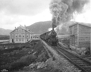
Haugastøl Station
|
Haugastøl
|
|
|---|---|

July 1912
|
|
| Location | Haugastøl, Hol Norway |
| Coordinates | 60°30′41″N 7°52′12″E / 60.51136°N 7.86990°ECoordinates: 60°30′41″N 7°52′12″E / 60.51136°N 7.86990°E |
| Elevation | 988.0 m |
| Operated by | Norges Statsbaner |
| Line(s) | Bergensbanen |
| Distance | 275.50 km |
| Platforms | 1 |
| History | |
| Opened | 1908 |
Haugastøl is a station on the Bergensbanen railway line in Norway. The station is located in the Hol municipality situated between the stations Ustaoset to the east and Finse to the west. The station is 275.5 km from Oslo if one follows the track over Roa. The altitude is 988 metres above sea level. The station was opened in 1908.
The Rallarvegen cycling and hiking path, which was originally constructed to aid the construction of the railway, starts at Haugastøl giving the station significant traffic during the summer. The station is also manned during the summer. Haugastøl is not among the main stations on the mountainous stretch, and the fast express trains do not serve the station.
The station building was designed by the architect Paul Armin Due (1870-1926) and is a hybrid between the National Romantic style and the Jugendstil. The building was renovated in 1963 with the addition of lavatories. In 2002 the Norwegian Directorate for Cultural Heritage declared the building worthy of protection.
...
Wikipedia
