Hartley Township, Union County, Pennsylvania
| Hartley Township, Pennsylvania | |
|---|---|
| Township | |

|
|
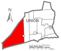
 Map of Union County, Pennsylvania highlighting Hartley Township |
|
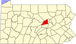
 Map of Pennsylvania highlighting Union County |
|
| Country | United States |
| State | Pennsylvania |
| County | Union |
| Settled | 1770 |
| Incorporated | 1811 |
| Area | |
| • Total | 79.7 sq mi (206.4 km2) |
| • Land | 79.6 sq mi (206.1 km2) |
| • Water | 0.1 sq mi (0.3 km2) |
| Population (2000) | |
| • Total | 1,714 |
| • Density | 21.5/sq mi (8.3/km2) |
| Time zone | EST (UTC-5) |
| • Summer (DST) | EDT (UTC-4) |
Hartley Township is a township in Union County, Pennsylvania, United States. The population was 1,714 at the 2000 census.
The unincorporated village of Laurelton, where the office for Bald Eagle State Forest is located, is in the township. R. B. Winter State Park one of 120 Pennsylvania state parks is in Hartley Township.
The Millmont Red Bridge and Halfway Lake Dam are listed on the National Register of Historic Places.
According to the United States Census Bureau, the township has a total area of 79.7 square miles (206 km2), of which, 79.6 square miles (206 km2) of it is land and 0.1 square miles (0.26 km2) of it (0.15%) is water.
Hartley Township is bordered by Centre County to the northwest, Lewis Township to the east, Snyder County to the south and Mifflin County to the west.
As of the census of 2000, there were 1,714 people, 648 households, and 473 families residing in the township. The population density was 21.5 people per square mile (8.3/km²). There were 1,139 housing units at an average density of 14.3/sq mi (5.5/km²). The racial makeup of the township was 99.18% White, 0.18% African American, 0.18% Asian, 0.12% Pacific Islander, and 0.35% from two or more races. Hispanic or Latino of any race were 0.18% of the population.
...
Wikipedia
