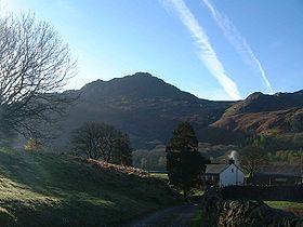
Harter Fell, Eskdale
| Harter Fell | |
|---|---|

Harter Fell as seen from Wha House Farm in Eskdale
|
|
| Highest point | |
| Elevation | 649 m (2,129 ft) |
| Prominence | c. 276 m |
| Parent peak | Scafell Pike |
| Listing | Marilyn, Hewitt, Wainwright, Nuttall |
| Coordinates | 54°23′18″N 3°12′15″W / 54.38833°N 3.20417°WCoordinates: 54°23′18″N 3°12′15″W / 54.38833°N 3.20417°W |
| Geography | |
| Location | Cumbria, England |
| Parent range | Lake District, Southern Fells |
| OS grid | SD218997 |
| Topo map | OS Landranger 96, Explorer OL6 |
Harter Fell is a mountain in the western part of the English Lake District located between the Eskdale and Duddon valleys. Its height is 649 m (2128 ft). There are several walking routes to the summit.
The headwaters of the Esk and Duddon are separated by a ridge falling south west from the summit of Crinkle Crags. This line of high ground continues over many twists and turns for 15 miles, finally meeting the sea on the slopes of Black Combe. From Crinkle Crags the first fells on this ridge are Hard Knott and Harter Fell, separated by Hardknott Pass. From Harter Fell the ridge continues over Green Crag, Great Worm Crag, Yoadcastle, Whitfell, Buck Barrow and Black Combe. Alfred Wainwright considered the latter hills unworthy of inclusion in his influential Pictorial Guide to the Lakeland Fells, stating that "south and west from Green Crag the scenery quickly deteriorates. This summit has therefore been taken as the boundary of fellwalking country." Later guidebook writers have disagreed, adding and the remainder of the range to their main volumes. Wainwright himself later relented and included these lesser hills in a supplementary volume, The Outlying Fells of Lakeland.
From the top of the pass a complex series of grassy knolls firms up into a ridge bearing south westward. This steps upward, first over Horsehow Crags and then the impressive gable-end of Demming Crag, before reaching the summit area. Further outcropping rock occurs on all sides, although little of it is of interest to climbers. Notable features are Maiden Castle, Brandy Crag and Mart Crag to the south east and Kepple Crag to the south. To the southwest is a broad and marshy saddle leading onto Green Crag and the moorlands of Birker Fell, the ongoing watershed. The southern and eastern flanks are heavily forested with conifers, legions of Forestry Commission trees sweeping down into the Duddon valley.
...
Wikipedia

