Hartbeespoort Dam
| Hartbeespoort Dam | |
|---|---|

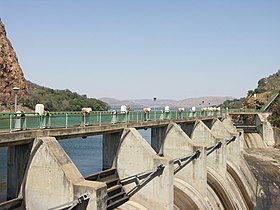
The crest gates added in 1970
|
|
|
Location of Hartbeespoort Dam in South Africa
|
|
| Official name | Hartbeespoort Dam |
| Country | South Africa |
| Location | North West Province |
| Coordinates | 25°44′51″S 27°52′1″E / 25.74750°S 27.86694°ECoordinates: 25°44′51″S 27°52′1″E / 25.74750°S 27.86694°E |
| Purpose | Irrigation and domestic use |
| Construction began | 1921 |
| Opening date | 1923 (renovated: 1969) |
| Owner(s) | Department of Water Affairs |
| Dam and spillways | |
| Type of dam | Arch dam |
| Impounds | Crocodile River |
| Height | 59 m |
| Length | 149.5 m |
| Width (base) | 22 m |
| Reservoir | |
| Creates | Hartbeespoort Dam Reservoir |
| Total capacity | 195,000,000 m3 |
| Catchment area | 4 120 km2 |
| Surface area | 2 062.8 ha |
| Hartbeespoort Dam bridge | |
|---|---|
| Carries | Motor vehicle traffic |
| Characteristics | |
| Width | Single lane |
| Statistics | |
| Toll | None |
Hartbeespoort Dam (also known as Harties) is an arch type dam situated in the North West Province of South Africa. It lies in a valley to the south of the Magaliesberg mountain range and north of the Witwatersberg mountain range, about 35 kilometers west of Pretoria. The name of the dam means "pass of the hartebeest" (a species of antelope) in Afrikaans. This "poort" in the Magaliesberg was a popular spot for hunters, where they cornered and shot the hartebeest. The dam was originally designed for irrigation, which is currently its primary use, as well as for domestic and industrial use. The dam has suffered from a hypertrophic state since the early 1970s. Mismanagement of waste water treatment from urban zones within the Hartbeespoort Dam catchment area is largely to blame, having distorted the food web with over 280 tons of phosphate and nitrate deposits.
The town of Hartbeespoort is situated close to the dam wall and the villages of Kosmos, Melodie, Ifafi, Meerhof and The Coves, Pecanwood, Westlake and several other Estates can be found alongside its banks. the town of Schoemansville was named after General Hendrik Schoeman, owner of the land during the 19th century.
In 1906, the government ordered a public inquiry into the feasibility of building an irrigation dam in the Hartbeespoort of the Magaliesberg. The engineer of the Department of Irrigation that led the inquiry, submitted a favourable report to the government and the Hartebeestpoort Act. 32 of 1914 was accepted by Parliament. As early as 1909 there were test holes drilled at the bottom of the river to determine whether the rock formation was suitable for building such a huge dam. The size of the catchment area was calculated, the water flow was measured and estimates made of the potential irrigable land. Downstream claims to the existing water stream were established. The topography of the riverbank and rock formations were examined to evaluate the viability of the poort for the construction project.
The construction of the dam officially started in August 1916. Initially work was delayed pending a court judgement with General Hendrik Schoeman and a certain Mr. Marshevin about the expropriation of their properties. The dispute was later resolved but discontent remained after a hastily passed law to facilitate the expropriation. In his book "Agter die Magalies", Bertus de Beer argues that the government acted in a heavy-handed manner to resolve a number of issues surrounding the construction of the dam. Mother Nature caused further delays due to flooding. In 1914 and again in 1918, huge amounts of construction wood washed down the river and were never recovered. During 1915, the wall of the Geldenhuysdam further up the river broke and the flooding of the site also caused a delay.
...
Wikipedia

