Harris, Scotland
| Harris | |
|---|---|
 |
|
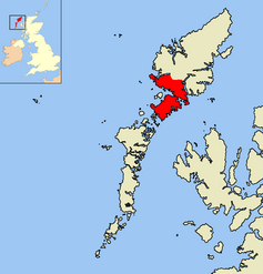
| Harris shown within the Outer Hebrides | |
| Population | 1,916 |
| Language |
Scottish Gaelic English |
| OS grid reference | NB155005 |
| Council area | |
| Lieutenancy area | |
| Country | Scotland |
| Sovereign state | United Kingdom |
| Post town | ISLE OF HARRIS |
| Postcode district | HS3 |
| Dialling code | 01859 |
| Police | Scottish |
| Fire | Scottish |
| Ambulance | Scottish |
| EU Parliament | Scotland |
| UK Parliament | |
| Scottish Parliament | |
Harris (also Scottish Gaelic: Na Hearadh, pronounced [nə ˈhɛɾəɣ]) is the southern and more mountainous part of Lewis and Harris, the largest island in the Outer Hebrides, Scotland. Although not an island itself, Harris is often referred to as the Isle of Harris, which is the former postal county and the current post town for Royal Mail postcodes starting HS3 or HS5. See HS postcode area. A person from Harris is known as a Hearach.
According to the 2011 Census, there are 1,212 Gaelic speakers (60%) in the Harris area.
Harris is most likely to be the island referred to as Adru (meaning thick, stout or bulky) on Ptolemy's map of the British Isles. In Old Norse, a Hérað was a type of administrative district, and the name may derive from that. An alternative origin is the Norse Hærri, meaning "higher" - a reference to the high hills, especially in comparison with the much flatter Lewis lying to the north. Most of the place names on Harris are Gaelicized Old Norse.
The Gaelic name "Na Hearadh" was also an earlier term for the Rinns of Islay.
Harris divides naturally into northern and southern parts which are separated by West and East Loch Tarbert. These halves are joined by a narrow isthmus at the main settlement of Tarbert (An Tairbeart or Tairbeart na Hearadh).
...
Wikipedia
