Harney Basin
| Harney Basin | |
| Endorheic basin | |
|
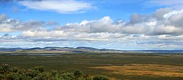
Harney Basin near Burns, Oregon
|
|
| Country | United States |
|---|---|
| State | Oregon |
| County | Harney County |
| Part of | Columbia Plateau |
| Parts | Frenchglen, Malheur Maar, Wright's Point |
| Lake | Harney Lake; Malheur Lake |
| River | Donner und Blitzen River; Silvies River |
| Location | Malheur Gap |
| - elevation | 4,111 ft (1,253 m) |
| - coordinates | 43°15′14″N 118°42′54″W / 43.25389°N 118.71500°WCoordinates: 43°15′14″N 118°42′54″W / 43.25389°N 118.71500°W |
| Highest point | |
| - elevation | 5,200 ft (1,585 m) (ecoregion 80e) |
| Lowest point | |
| - elevation | 4,000 ft (1,219 m) (ecoregion 80e) |
| Area | 3,855 km2 (1,488 sq mi) |
| Biome | Northern Basin and Range (ecoregion) |
|
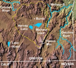
The Harney Basin (dashed yellow perimeter)
|
|
The Harney Basin is an endorheic basin in southeastern Oregon in the United States at the northwestern corner of the Great Basin. One of the least populated areas of the contiguous United States, it is located largely in northern Harney County, bounded on the north and east by the Columbia Plateau—within which it is contained, physiographically speaking—and on the south and west by a volcanic plain. The basin encompasses an area of 1,490 square miles (3,859 km2) in the watershed of Malheur Lake and Harney Lake. Malheur Lake is a freshwater lake, while Harney Lake is saline-alkaline.
The basin is bounded on the north by the southern end of the Blue Mountains. The ridge of Steens Mountain separates the basin from the watershed of the Alvord Desert to the southeast. No streams cross the volcanic plains that separate the basin from the watershed of the Klamath River to the southwest. The basin includes archeological sites of the Drewsey Resource Area.
The central basin receives an average of 6 inches (150 mm) of rain per year, with the surrounding mountains receiving an average of 15 inches (380 mm) per year. The center of the basin is flat and contains Malheur and Harney lakes, which receive the streams originating within the basin in the surrounding mountains, including the Silvies River from the north and the Donner und Blitzen River from the south. Harney Lake is the actual sink of the basin, connected in some years to Malheur Lake but currently separated by constantly changing sand dunes. Both lakes cycle between open water in wetter years and marshes in drier years. The wetlands around Malheur Lake and Harney Lake form a wetlands oasis in the basin, providing a habitat for many migratory bird species, including 2.5 million ducks each year. Malheur Lake and its surroundings are embraced by Malheur National Wildlife Refuge.
...
Wikipedia


