Hardt Railway
| Hardt Railway |
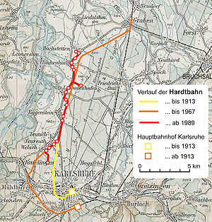
Historical development of the Hardt Railway
|
| Overview |
| Native name |
Hardtbahn |
| Locale |
Baden-Württemberg, Germany |
|
Route map
|
|
|
|
|
|
S 1S 11 |
|
|
|
junction with the Karlsruhe tram network |
|
|
|
Karlsruhe Städtisches Klinikum/Moltkestr. |
|
|
|
Karlsruhe Knielinger Allee |
|
|
|
Karlsruhe August-Bebel-Str. |
|
|
|
Karlsruhe Kurt-Schumacher-Str. |
|
|
0.0 |
Karlsruhe Haus Bethlehem |
|
|
|
Haus Betlehem loop |
|
|
|
|
|
|
|
|
|
|
1.3 |
Karlsruhe-Neureut Welschneureuter Str. |
|
|
1.8 |
Karlsruhe-Neureut Bärenweg |
|
|
2.0 |
Neureut |
|
|
2.3 |
Karlsruhe-Neureut Adolf-Ehrmann-Bad |
|
|
2.7 |
Karlsruhe-Neureut Kirchfeld |
|
|
|
Neureut Kirchfeld loop |
|
|
|
Industrial siding (freight only) |
|
|
|
| former trackbed to the old main station |
| (closed 1913, US airfield siding 1952-1974) |
|
|
|
|
Karlsruhe city boundary |
|
|
4.9 |
Eggenstein Süd |
|
|
5.4 |
Eggenstein Station |
|
|
5.9 |
Eggenstein Spöcker Weg |
|
|
6.6 |
Eggenstein Schweriner Str. |
|
|
|
| former trackbed to Graben-Neudorf |
| (closed 1990) |
|
|
|
|
Pfinz-Entlastungskanal |
|
|
7.2 |
Leopoldshafen Viermorgen |
|
|
8.1 |
Leopoldshafen Leopoldstr. |
|
|
8.5 |
Leopoldshafen Frankfurter Str. |
|
|
|
Leopoldshafen Frankfurter Str. loop |
|
|
9.2 |
(junction since 1989) |
|
|
|
former trackbed to Graben-Neudorf |
|
|
|
KIT Campus Nord |
|
|
|
(only for employees) |
|
|
10.5 |
Linkenheim Süd |
|
|
10.9 |
Linkenheim Friedrichstr. |
|
|
11.3 |
Linkenheim Rathaus |
|
|
11.9 |
Linkenheim Schulzentrum |
|
|
12.2 |
Hochstetten Grenzstr. |
|
|
12.7 |
Hochstetten Altenheim |
|
|
12.9 |
HochstettenS 1S 11
|
|
| | | |

