Happy Valley, South Australia
|
Happy Valley Adelaide, South Australia |
|||||||||||||
|---|---|---|---|---|---|---|---|---|---|---|---|---|---|

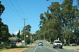
Western end of Windebanks Drive
|
|||||||||||||
| Population | 11,332 (2011 census) | ||||||||||||
| Postcode(s) | 5159 | ||||||||||||
| Location | 20 km (12 mi) from Adelaide | ||||||||||||
| LGA(s) | City of Onkaparinga | ||||||||||||
| Region | Southern Adelaide | ||||||||||||
| County | Adelaide | ||||||||||||
| State electorate(s) | Fisher | ||||||||||||
| Federal Division(s) | Kingston | ||||||||||||
|
|||||||||||||
Happy Valley is a metropolitan suburb of Adelaide, South Australia. It is located 20 km south of the Central Business District of Adelaide.
Within the suburb is the Happy Valley Reservoir accompanied by South Australia's largest water treatment plant, responsible for supplying water to much of the Adelaide metropolitan area.
Although it is now encompassed by suburbs, it still retains a relatively semi-rural character due to retention of native flora and vegetation surrounding the Happy Valley Reservoir, as well as parklands and golf courses along its border.
In November 1844, Daniel George Brock recorded in his diary details of a journey south from Adelaide. On his third day he rode past Thomas O’Halloran’s farm, on the hill noting that the land had little running water and was suitable for wheat farming. Some few kilometres to the east he came to Happy Valley. There, he noted, were ‘several substantial stone buildings, among which is a neat little chapel’.
Originally known by the Kaurna name of "Warekila" meaning 'place of changing winds', Happy Valley, a source suggested, was given its name by Edward Burgess, one of the first settlers in the area. Burgess, a staunch Methodist, arrived at Holdfast Bay on 20 January 1837. At some time during the next two years, Burgess made his home at Happy Valley and began farming. He was not alone: the South Australian Company had also purchased significant amounts of land in the area and was offering it to the settlers.
By 1866, Happy Valley was described as ‘an agricultural settlement lying near Dashwood’s Gully, a good district road connecting the two places. It lies near the postal village of O’Halloran Hill. There is a public pound and a Forester’s court in this place.’ By this time, too, wheat farming had been joined by wine grape growing. The settlement itself, although spread over a fair distance, incorporated an array of trades, a licensed school and chapel.
...
Wikipedia
