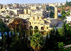
Hamah
|
Hama حماة |
|
|---|---|

Hama
|
|
| Location in Syria | |
| Coordinates: 35°08′N 36°45′E / 35.133°N 36.750°ECoordinates: 35°08′N 36°45′E / 35.133°N 36.750°E | |
| Country | Syria |
| Governorate | Hama |
| District | Hama |
| Subdistrict | Hama |
| Government | |
| • Governor | Abdul Razzaq al-Qutaini |
| Elevation | 305 m (1,001 ft) |
| Population (2004 census) | |
| • Total | 312,994 |
| • Ethnicities | Syrians |
| • Religions |
Sunni Islam Syriac Orthodox Church Greek Orthodox Church |
| Area code(s) | 33 |
| Climate | BSh |
| Website | www |
| Hama | ||||||||||||||||||||||||||||||||||||||||||||||||||||||||||||
|---|---|---|---|---|---|---|---|---|---|---|---|---|---|---|---|---|---|---|---|---|---|---|---|---|---|---|---|---|---|---|---|---|---|---|---|---|---|---|---|---|---|---|---|---|---|---|---|---|---|---|---|---|---|---|---|---|---|---|---|---|
| Climate chart () | ||||||||||||||||||||||||||||||||||||||||||||||||||||||||||||
|
||||||||||||||||||||||||||||||||||||||||||||||||||||||||||||
|
||||||||||||||||||||||||||||||||||||||||||||||||||||||||||||
| J | F | M | A | M | J | J | A | S | O | N | D |
|
73
11
3
|
54
14
3
|
49
18
5
|
32
23
9
|
10
29
13
|
3.8
34
17
|
0.4
36
20
|
0.1
36
20
|
1.8
34
17
|
21
28
12
|
40
20
7
|
67
13
4
|
| Average max. and min. temperatures in °C | |||||||||||
| Precipitation totals in mm | |||||||||||
| Source: Climate Charts | |||||||||||
| Imperial conversion | |||||||||||
|---|---|---|---|---|---|---|---|---|---|---|---|
| J | F | M | A | M | J | J | A | S | O | N | D |
|
2.9
53
37
|
2.1
57
38
|
1.9
64
42
|
1.3
74
48
|
0.4
85
55
|
0.1
93
63
|
0
97
68
|
0
97
68
|
0.1
93
63
|
0.8
82
54
|
1.6
67
44
|
2.6
56
39
|
| Average max. and min. temperatures in °F | |||||||||||
| Precipitation totals in inches | |||||||||||
...
Wikipedia

