Hailsham
| Hailsham | |
|---|---|
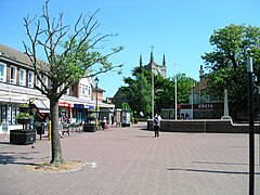
 Hailsham town centre |
|
| Hailsham shown within East Sussex | |
| Area | 19.4 km2 (7.5 sq mi) |
| Population | 20,476 (2011 Census) |
| • Density | 2,652/sq mi (1,024/km2) |
| OS grid reference | TQ589093 |
| • London | 61.4 miles (98.8 km) NNW |
| District | |
| Shire county | |
| Region | |
| Country | England |
| Sovereign state | United Kingdom |
| Post town | HAILSHAM |
| Postcode district | BN27 |
| Dialling code | 01323 |
| Police | Sussex |
| Fire | East Sussex |
| Ambulance | South East Coast |
| EU Parliament | South East England |
| UK Parliament | |
| Website | http://www.hailsham-tc.gov.uk/ |
Hailsham is a civil parish and the largest of the five towns in the Wealden district of East Sussex, England. It is mentioned in the Domesday Book, where it is called Hamelesham. The town of Hailsham has a history of industry and agriculture.
The name ‘Hailsham’ is thought to come from the Saxon ‘Haegels Ham’, meaning the clearing or settlement of Haegel, Hella or a similar name, possibly even 'Aella’s Ham’, the clearing of Aella the Saxon. The name of the town has been spelt in various ways through the ages from ‘Hamelsham’ (as it was referred to in the Domesday Book), ‘Aylesham’ in the 13th century, and later Haylesham, to its present spelling.
The site of Hailsham has been inhabited since at least the Neolithic age. It was an Ancient British settlement that existed before the Romans invaded Kent and Sussex in 43 AD. The Anglo Saxons invaded Sussex in the year 477 AD. The Saxons are thought to have invaded at an original landing place at Selsey. According to the Anglo-Saxon Chronicle, in 491 AD they attacked and took the British stronghold of Anderida which was the fort that is believed to have been built by the Ancient British and the Romans at what is now Pevensey, just a few miles from Hailsham, thereby consolidating their conquest and forming the small kingdom of the South Saxons, or Sussex. In Roman and Saxon times, the lowland marsh area between Anderida and the site of Hailsham, today known as the Pevensey Levels, is presumed to be un-reclaimed at that time, so that much of the levels would have been a saltmarsh and at high tide, a lagoon. The link between Hailsham and the levels is preserved in the name of the access routes such as Marshfoot Lane and Saltmarsh Lane.
The manor of Hailsham is recorded in the Domesday Survey completed by the Normans in 1086, 20 years after the conquest.
...
Wikipedia

