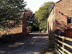
Haile, Cumbria
| Haile | |
|---|---|
 Haile village |
|
| Haile shown within Cumbria | |
| Population | 617 (2011) |
| OS grid reference | NY035091 |
| Civil parish |
|
| District | |
| Shire county | |
| Region | |
| Country | England |
| Sovereign state | United Kingdom |
| Post town | Egremont |
| Postcode district | CA22 |
| Dialling code | 01946 |
| Police | Cumbria |
| Fire | Cumbria |
| Ambulance | North West |
| EU Parliament | North West England |
| UK Parliament | |
Haile is a small village and civil parish in Copeland District, in the county of Cumbria. Nearby settlements include the town of Egremont and the villages of Thornhill and Beckermet. For transport there is the A595 road nearby. The village stands high, and is exposed to the west winds. The parish is situated near the river Ellen, and comprises the townships of Hale and Wilton.
In 1870-72, John Marius Wilson's Imperial Gazetteer of England and Wales described Haile like this:
"HAILE, or HALE, a parish in Whitehaven district, Cumberland; near Copeland forest, the river Eden, and the Whitehaven and Furness railway, 2½ miles SSE of Egremont. It includes the hamlet of Wilton; and its post town is Egremont, under Whitehaven. Acres, 3, 220."
Haile countryside
"Haile Parish Church - a small church nestling in a vale just outside the village of Haile surrounded by a picturesque church yard and mature trees. The little church at Haile, with no dedication, has Georgian plain arched windows, but the walls are medieval. The west porch was added by Ferguson in 1882, and the Church restoration took place mainly in 1883. a South-East quoin in the nave is part of a Saxon cross-shaft, with scrolls. Outside against the West wall is a monument to John Ponsonby (1670, while the window depicting St George and the dragon, is a memorial to a later Ponsonby, who died in 1952. The church is linked with the Egremont Team Ministry. The Rev'd Simon Cake (CA) takes lead responsibility for Haile".
It has a population of 617 according to the 2011 Census. When analyzing the population graph, from 1961 to 2011 the population grew by 500 when comparing the data sets from the Neighborhood Statistics and the Vision of Britain website. However this large scale rise in population isn't truly valid as the two contrasting websites use different boundaries to outline Haile. The Neighborhood Statistics Census highlights Haile as a much larger area than the Vision of Britain site therefore explaining the massive change in population size. This is because of the boundary change in April 1935 transferring an extra 45 acres to the area. Therefore both websites are accurate for the period they represent.
When discussing the occupations of Haile's population, through time it highlights the changes in living during the 130-year period between 1881 and 2011. In 1881 the majority of jobs were in the agricultural sector, having a total of around 70 people out of 266 people in work. There was a high number of unknown occupations for women, which could be because of a lack of information to record these statistics or because their occupations were illegal. Also, during this time the majority of workers were male with 183/266 out of the total workforce. However, comparing the occupations to the 2011 census shows the change in equality in terms of the number of people working, with 164 males and 161 female. The jobs have also shifted from the agricultural sector to the professional and public sector. In 1881, Haile only had 3 people who were known professionals, compared to 108 in 2011. Therefore in terms of occupations Haile has followed a similar trend to the rest of Britain.
...
Wikipedia

