Hadji Muhtamad
| Hadji Muhtamad | |
|---|---|
| Municipality | |
 Location within Basilan province |
|
| Location within the Philippines | |
| Coordinates: 6°38′N 121°37′E / 6.63°N 121.62°ECoordinates: 6°38′N 121°37′E / 6.63°N 121.62°E | |
| Country | Philippines |
| Region | Autonomous Region in Muslim Mindanao (ARMM) |
| Province | Basilan |
| District | Lone district of Basilan |
| Founded | August 25, 2007 |
| Barangays | 10 (see Barangays) |
| Government | |
| • Type | Sangguniang Bayan |
| • Mayor | Jamar A. Mansul |
| Population (2015 census) | |
| • Total | 25,085 |
| Time zone | PST (UTC+8) |
| ZIP code | 7301 |
| IDD : area code | +63 (0)62 |
| 150712000 | |
| Electorate | 8,135 voters as of 2016 |
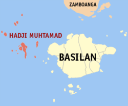
Hadji Muhtamad, officially the Municipality of Hadji Muhtamad (Chavacano: Municipalidad de Hadji Muhtamad; Cebuano: Lungsod sa Hadji Muhtamad; Filipino: Bayan ng Hadji Muhtamad), is a municipality in the province of Basilan in the Autonomous Region in Muslim Mindanao (ARMM) of the Philippines. The population was 25,085 at the 2015 census. In the 2016 electoral roll, it had 8,135 registered voters.
Its territory includes the Pilas Islands and surrounding islets, west of Basilan Island.
Hadji Muhtamad was created out of the 10 barangays of Lantawan that were not on Basilan Island, through Muslim Mindanao Autonomy Act No. 200, which was subsequently ratified in a plebiscite held on August 25, 2007.
Hadji Muhtamad is politically subdivided into 10 barangays.
In the 2015 census, Hadji Muhtamad had a population of 25,085.
In the 2016 electoral roll, it had 8,135 registered voters.
...
Wikipedia

