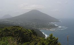
Hachijo Island
|
Native name: 八丈島 Nickname: Hachijō Island |
|
|---|---|

Hachijō-fuji
|
|
 |
|
| Geography | |
| Location | Izu Islands |
| Coordinates | 33°06′34″N 139°47′29″E / 33.10944°N 139.79139°E |
| Archipelago | Izu Islands |
| Area | 62.52 km2 (24.14 sq mi) |
| Length | 14 km (8.7 mi) |
| Width | 7.5 km (4.66 mi) |
| Coastline | 58.91 km (36.605 mi) |
| Highest elevation | 854.3 m (2,802.8 ft) |
| Administration | |
|
Japan
|
|
| Demographics | |
| Population | 8363 (September 2009) |
Hachijō-jima (八丈島?) is a volcanic Japanese island in the Philippine Sea. The island is administered by Tōkyō and located approximately 287 kilometres (178 mi) south of the Special Wards of Tōkyō. It is the southernmost and most isolated of the Izu Seven Islands group of the seven northern islands of the Izu archipelago. The chief community on the island is Mitsune; other communities are Nakanogo, Kashitate, and Ōkago all of which are administratively part of the town of Hachijō under Hachijō Subprefecture of Tokyo Metropolis. As of 2009[update], the island's population was 8,363 people living on 63 km2. The highest elevation is about 850 metres (2,790 feet). Hachijō-jima is also within the boundaries of the Fuji-Hakone-Izu National Park.
Hachijō-jima is a compound volcanic island 14.5 kilometres (9.0 miles) in length with a maximum width of 8 kilometres (5.0 miles). The island is formed from two stratovolcanoes. Higashi-yama (東山?), also called Mihara-yama (三原山?), has a height of 701 metres (2,300 ft), and was active from 100,000 BC to around 1700 BC, has eroded flanks and retains a distinctive caldera. Nishi-yama (西山?), also called Hachijō-fuji (八丈富士?)) is the highest point on the island and is the tallest peak of the entire Izu island chain, with a height of 854 metres (2,802 ft). The summit is occupied by a shallow caldera with a diameter of 400 metres (1,300 feet) and a depth of around 50 metres (160 feet). It is rated as a Class-C active volcano by the Japan Meteorological Agency with eruptions recorded in recent history in 1487, 1518, 1522–1523, 1605 and 1606. In between these two peaks are over 20 flank volcanoes and pyroclastic cones.
...
Wikipedia
