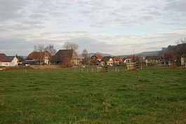
Höchstetten, Switzerland
| Höchstetten | ||
|---|---|---|

Höchstetten village
|
||
|
||
| Coordinates: 47°9′N 7°38′E / 47.150°N 7.633°ECoordinates: 47°9′N 7°38′E / 47.150°N 7.633°E | ||
| Country | Switzerland | |
| Canton | Bern | |
| District | Emmental | |
| Area | ||
| • Total | 2.64 km2 (1.02 sq mi) | |
| Elevation | 480 m (1,570 ft) | |
| Population (Dec 2015) | ||
| • Total | 270 | |
| • Density | 100/km2 (260/sq mi) | |
| Postal code | 3429 | |
| SFOS number | 0410 | |
| Surrounded by | Alchenstorf, Heinrichswil-Winistorf (SO), Hellsau, Koppigen, Willadingen | |
| Website |
www SFSO statistics |
|
Höchstetten is a municipality in the administrative district of Emmental in the canton of Bern in Switzerland.
Höchstetten is first mentioned in 1360 as Hönstetten.
The remains of mesolithic and neolithic settlements have been found in the Sandhubel, Rüteliacker and Linzifeld areas of Höchstetten. During the Early Middle Ages there was a nearby settlement that left graves at Holenmatt. Throughout its history, the small village of Höchstetten was dependent on the larger village of Koppigen. Starting in the 1820s it joined together with Hellsau to share a primary school. Today, the two communities share the Moos school house, which was built in 1976. The local economy is based on agriculture and small businesses with many residents commuting to nearby towns for work.
Höchstetten has an area of 2.64 km2 (1.02 sq mi). Of this area, 1.87 km2 (0.72 sq mi) or 70.8% is used for agricultural purposes, while 0.52 km2 (0.20 sq mi) or 19.7% is forested. Of the rest of the land, 0.19 km2 (0.073 sq mi) or 7.2% is settled (buildings or roads), 0.02 km2 (4.9 acres) or 0.8% is either rivers or lakes.
Of the built up area, housing and buildings made up 5.7% and transportation infrastructure made up 1.1%. Out of the forested land, all of the forested land area is covered with heavy forests. Of the agricultural land, 59.5% is used for growing crops and 10.6% is pastures. All the water in the municipality is flowing water.
The municipality is located on the Bern-Zürich highway.
On 31 December 2009 Amtsbezirk Burgdorf, the municipality's former district, was dissolved. On the following day, 1 January 2010, it joined the newly created Verwaltungskreis Emmental.
The blazon of the municipal coat of arms is Argent on a Chief and Pale Gules a Mullet Or.
Höchstetten has a population (as of December 2015[update]) of 270. As of 2010[update], 3.1% of the population are resident foreign nationals. Over the last 10 years (2000-2010) the population has changed at a rate of 1.6%. Migration accounted for 4%, while births and deaths accounted for 2%.
...
Wikipedia


