Gurley, Alabama
| Gurley, Alabama | ||
|---|---|---|
| Town | ||

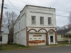
The Old Gurley Town Hall which began toppling during a windstorm in early November 2015, was a contributing property to the Gurley Historic District which was added to the National Register of Historic Places on June 2, 2004.
|
||
|
||
 Location in Madison County and the state of Alabama |
||
| Coordinates: 34°42′0″N 86°22′35″W / 34.70000°N 86.37639°WCoordinates: 34°42′0″N 86°22′35″W / 34.70000°N 86.37639°W | ||
| Country | United States | |
| State | Alabama | |
| County | Madison | |
| Area | ||
| • Total | 3.5 sq mi (9.1 km2) | |
| • Land | 3.5 sq mi (9.1 km2) | |
| • Water | 0 sq mi (0 km2) | |
| Elevation | 640 ft (195 m) | |
| Population (2010) | ||
| • Total | 801 | |
| • Density | 228/sq mi (88.0/km2) | |
| Time zone | Central (CST) (UTC-6) | |
| • Summer (DST) | CDT (UTC-5) | |
| ZIP code | 35748 | |
| Area code(s) | 256 | |
| FIPS code | 01-32440 | |
| GNIS feature ID | 0119509 | |
Gurley is a town in Madison County, Alabama, United States, and is included in the Huntsville-Decatur Combined Statistical Area. As of the 2010 census, the population of the town was 801.
The community takes its name from the Gurley family, who settled in the area in 1817. The town gradually formed around a water and coaling stop of the Memphis & Charleston Railroad and was originally known as Gurley's Tank. In 1866, the post office opened, and the name was changed to Gurleysville; it was later shortened back to Gurley. Gurley was incorporated in 1891 with 250 residents. Soon after, the population peaked at 1,000. The business district was nearly destroyed by fire in 1923, when a bucket brigade was able to save only two businesses. Most of the town is now included in the Gurley Historic District, which was listed on the National Register of Historic Places in 2004.
Gurley is located at 34°42′1″N 86°22′35″W / 34.70028°N 86.37639°W (34.700164, -86.376469).
According to the U.S. Census Bureau, the town has a total area of 3.5 square miles (9.1 km2), all land.
Note: From the 1940 Census until 1970, Gurley ceased to appear on the census rolls. This was likely due to either disincorporation or loss/lapse of its charter in the 1930s. At some point in the 1960s, it was reincorporated.
As of the census of 2000, there were 876 people, 346 households, and 241 families residing in the town. The population density was 313.9 people per square mile (121.2/km²). There were 379 housing units at an average density of 135.8 per square mile (52.4/km²). The racial makeup of the town was 81.85% White, 15.41% Black or African American, 0.46% Native American, 0.34% Asian, 0.57% from other races, and 1.37% from two or more races. 2.05% of the population were Hispanic or Latino of any race.
...
Wikipedia

