Grevena (regional unit)
|
Grevena Περιφερειακή ενότητα Γρεβενών |
|
|---|---|
| Regional unit | |

Municipalities of Grevena
|
|
 Grevena within Greece |
|
| Coordinates: 40°0′N 21°20′E / 40.000°N 21.333°ECoordinates: 40°0′N 21°20′E / 40.000°N 21.333°E | |
| Country | Greece |
| Region | West Macedonia |
| Capital | Grevena |
| Area | |
| • Total | 2,291 km2 (885 sq mi) |
| Population (2011) | |
| • Total | 31,757 |
| • Density | 14/km2 (36/sq mi) |
| Postal codes | 51x xx |
| Area codes | 24620, 24920 |
| ISO 3166 code | GR-51 |
| Car plates | ΡΝ |
| Website | www |
Grevena (Greek: Περιφερειακή ενότητα Γρεβενών) is one of the regional units of Greece. It is part of the region of West Macedonia. Its capital is the town of Grevena.
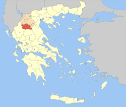
Grevena borders the regional units of Ioannina (Epirus) to the west, Kastoria to the northwest, Kozani to the north and east, Larissa to the southeast and Trikala to the south.
The Pindus mountains cover the western part of the regional unit. Other mountain ranges are Chasia in the south and Vourinos in the northeast. The longest river is Aliakmon which flows in the north and the east.
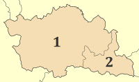
The regional unit Grevena is subdivided into 2 municipalities. These are (number as in the map in the infobox):
Grevena was created as a prefecture (Greek: Νομός Γρεβενών) in 1964, out of parts of the prefectures of Kozani and Larissa. As a part of the 2011 Kallikratis government reform, the regional unit Grevena was created out of the former prefecture Grevena. The prefecture had the same territory as the present regional unit. At the same time, the municipalities were reorganised, according to the table below.
The region's economy relies on farming and agriculture. Wheat and legume crops (mostly chickpeas) cover most of the cultivated areas. Livestock production (including goat and lamb) is also strong. An increasing portion of the farming output is produced under organic farming or low input practices. Other main sources of income include ecotourism, forest industry and the ski resort of Vasilitsa, which is a popular destination for winter holidays.
...
Wikipedia
