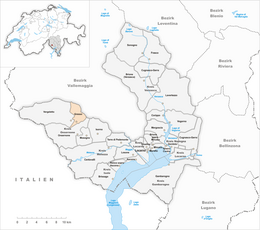
Gresso
| Gresso | ||
|---|---|---|
| Former municipality of Switzerland | ||
 |
||
|
||
| Coordinates: 46°13′N 8°37′E / 46.217°N 8.617°ECoordinates: 46°13′N 8°37′E / 46.217°N 8.617°E | ||
| Country | Switzerland | |
| Canton | Ticino | |
| District | Locarno | |
| Government | ||
| • Mayor | Sindaco | |
| Area | ||
| • Total | 11.08 km2 (4.28 sq mi) | |
| Elevation | 996 m (3,268 ft) | |
| Population (December 2004) | ||
| • Total | 35 | |
| • Density | 3.2/km2 (8.2/sq mi) | |
| Postal code | 6611 | |
| SFOS number | 5109 | |
| Surrounded by | Maggia, Onsernone, Vergeletto | |
| Website | SFSO statistics |
|
Gresso is a former municipality in the district of Locarno in the canton of Ticino in Switzerland. The municipality was formed in 1882 by splitting from Vergeletto. On 10 April 2016 the former municipalities of Vergeletto, Gresso, Mosogno and Isorno merged into the municipality of Onsernone.
The discovery of a Roman tomb from the 1st-2nd Century AD, with pottery and coins, proves that Gresso was part of the outer-most reaches of the Vicus of Muralto. The modern village of Gresso is first mentioned in 1316 as Agrassio. Until 1803, Gresso was part of the Squadra of Russo (now Onsernone), one of five Squadre, that formed the medieval community of Onsernone.
The village church has always been part of the parish of Vergeletto. The Chapel of S. Orsola was built in 1703 and rebuilt in 1730. It was renovated in the late 20th Century.
The village didn't have a drivable road until 1885. The local economy was based on agriculture, animal husbandry, and, for a time, emigration. Most of the population is elderly, the few younger residents have either moved away or commute to Locarno.
Gresso had an area, as of 1997[update], of 11.08 square kilometers (4.28 sq mi). Of this area, 0.17 km2 (0.066 sq mi) or 1.5% is used for agricultural purposes, while 6.77 km2 (2.61 sq mi) or 61.1% is forested. Of the rest of the land, 0.09 km2 (22 acres) or 0.8% is settled (buildings or roads), 0.19 km2 (0.073 sq mi) or 1.7% is either rivers or lakes and 1.77 km2 (0.68 sq mi) or 16.0% is unproductive land.
Of the built up area, housing and buildings made up 0.3% and transportation infrastructure made up 0.4%. Out of the forested land, 52.2% of the total land area is heavily forested and 5.7% is covered with orchards or small clusters of trees. Of the agricultural land, 1.3% is used for growing crops. All the water in the municipality is flowing water. Of the unproductive areas, 11.1% is unproductive vegetation and 4.9% is too rocky for vegetation.
...
Wikipedia


