Grenoble-Isère Airport
|
Alpes–Isère Airport Aéroport Alpes–Isère |
|||||||||||||||
|---|---|---|---|---|---|---|---|---|---|---|---|---|---|---|---|
 |
|||||||||||||||
| Summary | |||||||||||||||
| Airport type | Public | ||||||||||||||
| Operator | Société d'Exploitation de l'Aéroport de Grenoble (SEAG) | ||||||||||||||
| Serves | Grenoble, France | ||||||||||||||
| Location | Saint-Étienne-de-Saint-Geoirs | ||||||||||||||
| Elevation AMSL | 1,302 ft / 397 m | ||||||||||||||
| Coordinates | 45°21′47″N 005°19′46″E / 45.36306°N 5.32944°E | ||||||||||||||
| Website | grenoble-airport.com | ||||||||||||||
| Maps | |||||||||||||||
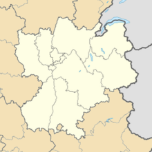
 Location of Rhône-Alpes region in France |
|||||||||||||||
| Location of airport in Rhône-Alpes region | |||||||||||||||
| Runways | |||||||||||||||
|
|||||||||||||||
| Statistics (2014) | |||||||||||||||
|
|||||||||||||||
|
Source: French AIP
|
|||||||||||||||
| Passengers | 320,647 |
|---|---|
| Passenger Change 13-14 |
|
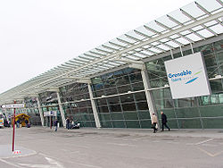
Alpes–Isère Airport (formerly Grenoble-Isère Airport) or Aéroport Alpes–Isère (IATA: GNB, ICAO: LFLS), is an international airport serving Grenoble which is situated 2.5 km north-northwest of Saint-Étienne-de-Saint-Geoirs and 40 km northwest of Grenoble, both communes in the Isère, département of France. The airport handled 456,062 passengers in 2009 and mostly features winter seasonal leisure traffic.
Formerly known as Grenoble–Saint-Geoirs Airport since 1968 Winter Olympics, the appellation, Isere, refers to the department of Isère. A campus of the École nationale de l'aviation civile is also located at the airport.
Coach links connect the airport with the centre of Grenoble.
...
Wikipedia

